How Can Evaluation Improve Sustainable Development?
Understanding the Nexus of Natural and Human Systems
Monday March 2nd – 2:15 –3:30 pm
Institute for Food, Nutrition and Health
Cook Campus
Rm. 101
Dr. Juha I. Uitto, Director
Independent Evaluation Office, Global Environment Facility
Evaluating environmental programs and projects in developing countries.
Drawing on over two decades of global evaluation experience, Dr. Uitto highlights the strategic role
evaluators play in understanding and enhancing the impact of environmental programs and projects in
developing countries. Understanding the differing geographic and time scales of natural and human
systems is crucial to assessing the complex dynamic systems in which the interventions operate and
interact. This is a needed corrective to the usual approach to evaluation, as in policymaking generally, in
which the environmental foundation has received relatively less attention. Dr. Uitto will also discuss the
use of geospatial data and analysis for improving international development evaluations.
The GEF (http://www.thegef.org/) has provided close to $20 billion in grant funding and mobilized an
additional $107 billion in co-financing to more than 4,700 projects in 170 countries.
Following his talk, Dr. Uitto will be available to discuss international internships
and project work opportunities with interested graduate students and faculty.
Contacts: Prof. Hal Salzman HSalzman@Rutgers.edu or Dr. Marjorie Kaplan mbk65@envsci.rutgers.edu
Sponsored by: Rutgers Global, Rutgers EJ Bloustein School of Planning and Public Policy, Rutgers Climate Institute,
International Development Interest Group and offered as part of E.J. Bloustein School’s “International Development”
course.
27 February 2020
26 February 2020
A quick lesson on hydrographs
Here is a quick video tutorial on watersheds and hydrographs. Can you read a hydrograph?
25 February 2020
Presentation tip
A great presentation tip from the GradHacker Blog:
Are you giving a talk to cats? No? Then you should probably put the laser pointer away.
Are you giving a talk to cats? No? Then you should probably put the laser pointer away.
24 February 2020
Soils Quote of the Day
“A cloak of loose, soft material, held to the Earth’s hard surface by gravity, is all that lies between life and lifelessness.”
- Wallace H. Fuller, in Soils of the Desert Southwest, 1975.
22 February 2020
Healthy guiding
Jan Van Haver's story of how Google Maps connected with a healthier lifestyle is just one example of creative thinking about getting people outdoors.
18 February 2020
Mapping very large lakes
Visual Capitalist has posted a pretty amazing mapfographic that compares the 25 largest lakes in the world. The remarkable twist is that it overlays 20 of those on a base map of the 5 Great Lakes, which makes the unfamiliar seem a little more familiar.
17 February 2020
Brian Rose photos of Atlantic City
With many of our students returning from the NJ ASLA meeting in Atlantic City, this is a great time to revisit Terrain.org's photo essay of a series of Atlantic City photos by Brian Rose. The photos and accompanying quotes document the city's troubling juxtaposition of glam and depression.
If you missed the meeting, maybe you should consider the MAC-URISA 2020 meeting in AC.
If you missed the meeting, maybe you should consider the MAC-URISA 2020 meeting in AC.
16 February 2020
Cycling through the canopy
This video captures a remarkable bicycle experience where cyclists can ride a 700m circle elevated through the canopies of trees. For readers looking for more details, Landezine has a beautifully illustrated article about the design. But for the rest, this video is a relaxing hint at this amazing experience.
And, it has been mapped.
And, it has been mapped.
10 February 2020
Geodetic Task Force
Here is a great chance for GIS professionals and students to get more involved in a process that could shape NJ GIS and mapping for decades to come:
A new task force is forming, so that a comprehensive understanding of the new datums being put forth by the National Geodetic Survey, and the potential impacts, can be provided to the NJGF community.All who are interested are welcome to join the Geodetic Task Force. Please contact the Task Force Chair, Edith Konopka, for more information and/or to sign-up.The first meeting of the New Jersey Geospatial Forum Geodetic Task Force has been scheduled for Wednesday, March 11, 2020, 1:30 - 3:30 pm at 300 Riverview Plaza, Trenton, Room 402, which is on the fourth floor. Please bring photo ID with you, and allow time to sign-in with the guard at the front desk.The agenda for the first meeting is:- create list of specific goals for the task force, referencing the mission statement provided by the NJGF Executive Committee- discuss briefly the US National Geodetic Survey proposed alternatives for the new NJ State Plane coordinate system.The mission statement of the Geodetic Task Force is:To get a comprehensive understanding of the new datums being put forth by the National Geodetic Survey and potential impacts and plan to implement statewide.Directions and a map to 300 Riverview PlazaThe current proposed alternatives from NGS for the new State Plane coordinate system
07 February 2020
Climate talk
Diane McKnight
Title:
Trouble Ahead Trouble Behind: Acid Mine Drainage & Climate Change in
the Rocky Mountains
Diane M. McKnight is a Professor in the Department of Civil,
Environmental and Architectural Engineering, a member of the Environmental
Engineering program faculty and a Fellow of the Institute of Arctic and Alpine
Research at the University of Colorado. Her research focuses on the coupling of
hydrology and water quality in streams and lakes, and the consequences for
aquatic ecosystems and water supplies.
March
4th, 2020
Poster Session 3-4:30pm;
Weeks Hall of Engineering, 2nd Floor Atrium
Lecture 5pm 102
Weeks Hall of Engineering
Registration: https://tinyurl.com/yzms78hh
05 February 2020
National Parks and Parklands about 1 person
Someone asked me yesterday if there were many National Parks devoted to one person. Well, I said, there are lots about individual presidents (Adams NHP would count as 2 or 3?) so we should exclude them.
Harriet Tubman
Booker T. Washington
Eleanor Roosevelt
Maggie L Walker
Frederick Law Olmsted
Thomas Edison
Edgar Allen Poe
Augustus Saint-Gaudens
Martin Luther King Jr.
Thaddeus Kościuszko
César E. Chávez
John Muir
Eugene O'Neill
Thomas Stone
Jean Lafitte
Frederick Douglass
George Rogers Clark
Clara Barton
Charles Pinckney
Carter G. Woodson *
Carl Sandburg *
Mary McLeod Bethune *
The NPS uses a short "nickname" for parks. All of these use the person's name as the nickname except for the three marked with asterisks. These each add a variation on house to the name, but I don't think it represents a major change in the way that the Park Service treats those sites. Similarity, I don't know why Edgar Allen Poe couldn't be the Edgar Allen Poe House.
Almost none of these are really just about one person. That person represents something else. Olmsted is about landscape architecture and parks and cities. Edison is about the ways that innovation transformed America.
Who else represents a truly American Experience? When you include arts, it opens up some interesting conversations. Who should get a single person National Park site?
Frank Lloyd Wright
Ed Orgeron
George Lucas
Elvis
Ernest Hemingway
04 February 2020
Development moratorium
The Wall Street Journal writes about a Southern boomtown, Lake Wylie, South Carolina, which recently issued a 16-month moratorium on new development. Is that legal? Seems like this is in line with the 2002 Supreme Court decision about the moratoria used by the Tahoe Regional Planning Agency.
How rapidly is development happening?
Presumably the WSJ thinks this case is a harbinger of things to come. But which parts?
How rapidly is development happening?
It isn’t clear whether a moratorium will have the intended effect. There are more than 3,000 homes and apartments approved for Lake Wylie that are in various stages of construction.And the water/sewer bills are reportedly skyrocketing as they struggle to accommodate the rapid increase in demand.
Presumably the WSJ thinks this case is a harbinger of things to come. But which parts?
03 February 2020
USGS Topo Quad Maps
In class today we will be talking about ways to access the free USGS topographic quads for NJ online.
It is amazing to me to think how much the use of these has changed aver the years even though the maps themselves have changed so little. For those that are new to the maps, I am sharing some different scenes from around New Jersey that may be of interest. Just click on each and they'll expand.
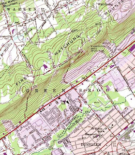
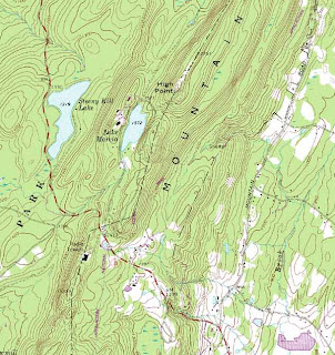
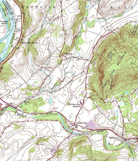
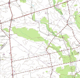
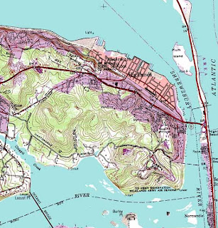
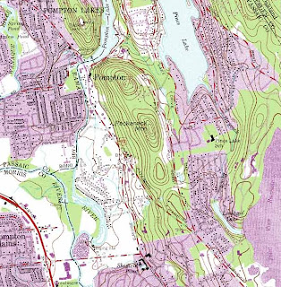
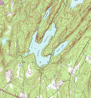
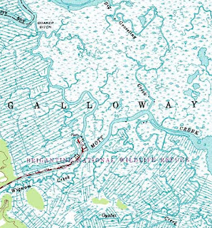
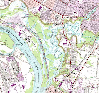
A special thanks goes out to Mike Siegel and the Rutgers Cartography Lab. This is a great resource for students and for pros. A national resource is the Libre Map Project, but it is a bit harder for first time users.
It is amazing to me to think how much the use of these has changed aver the years even though the maps themselves have changed so little. For those that are new to the maps, I am sharing some different scenes from around New Jersey that may be of interest. Just click on each and they'll expand.


A special thanks goes out to Mike Siegel and the Rutgers Cartography Lab. This is a great resource for students and for pros. A national resource is the Libre Map Project, but it is a bit harder for first time users.
Subscribe to:
Posts (Atom)


