The latest blog posting on the Lower Raritan Watershed Partnership's website is a Joe Mish description of the region's red shale as a touchstone of experiencing the river. But on the sidebar you will also see upcoming events that include a stream cleanup this weekend.
And if you dig a little deeper, you can find Heather Fenyk's list of the Top 10 Environmental Issues for the LRWP in 2019.
Showing posts with label raritan. Show all posts
Showing posts with label raritan. Show all posts


27 January 2019
Top 10 issues for the Lower Raritan
At Rutgers, we famously sit "on the banks of the Old Raritan." So it has been great watching the university become increasingly interested in the river over the past decade.
A great place to start is this list of the Top 10 Environmental Problems facing the Lower Raritan Watershed in 2019. The list is written by Heather Fenyk, President of the Lower Raritan Watershed Partnership. Her list is great because it integrates scientific issues like biodiversity with institutional issues like the inability to develop a regional planning framework.
A great place to start is this list of the Top 10 Environmental Problems facing the Lower Raritan Watershed in 2019. The list is written by Heather Fenyk, President of the Lower Raritan Watershed Partnership. Her list is great because it integrates scientific issues like biodiversity with institutional issues like the inability to develop a regional planning framework.
11 February 2016
Wildlife
Many would think that New Brunswick and New Jersey are a terrible place for wildlife. Admittedly, we could do a lot to make it better. But there is a lot already here.
Just a short walk from our campus is the Raritan River which helps provide critical habitat for an amazingly diverse community of plants and animals. Bald eagles and peregrine falcons regular work the river near us and Joe Mish has written about some of the not-so-hidden ecology on the banks. Don't just read it. Head and see some great places in our backyard.
Just a short walk from our campus is the Raritan River which helps provide critical habitat for an amazingly diverse community of plants and animals. Bald eagles and peregrine falcons regular work the river near us and Joe Mish has written about some of the not-so-hidden ecology on the banks. Don't just read it. Head and see some great places in our backyard.
12 May 2015
Saving land On the Banks
The already great Ken Lockwood Gorge is getting better, thanks to the NJCF.
27 April 2015
A hidden surprise
We spent the fall 2014 semester studying the Lower Raritan Watershed and couldn't keep our eyes of the properties around the Raritan Center. They seemed so central to everything that happens in the LRW. But this site, populated with busy warehouses, a major hotel, and some fascinating wetlands also contained some hidden surprises we were told. As a former WWII Army arsenal, there are some unexploded ordinance here and there. Ha! Is that really a thing today?
Yes.
Yes.
21 April 2015
25 August 2014
Lower Raritan partners and possible friends
The Lower Raritan Watershed is a large area and there are a lot of different groups that are either interested in it, or useful to those interested in the watershed. For our students, this list gives you some to explore, but is not close to being complete. It avoids companies and government groups except for environmental commissions.
Edison Wetlands Association
Riverkeeper
Lawrence Brook Watershed Partnership
The Watershed Institute
Central Jersey Bicycle Club
Raritan River Project at No Water No Life
American Littoral Society
Edison Greenways Group
East Coast Greenway
Highland Park Environmental Commission
Cranbury Environmental Commission
NJ Audubon
Endangered New Jersey
The NYNJCTBotany site has plant inventories for many sites within the watershed including (but not limited to) the Monmouth Battlefield State Park (in Monmouth County), Washington Valley Park (is Somerset County), Triple C Ranch (in Middlesex County), and the Watchung Reservation (in Union County).
Edison Wetlands Association
Riverkeeper
Lawrence Brook Watershed Partnership
The Watershed Institute
Central Jersey Bicycle Club
Raritan River Project at No Water No Life
American Littoral Society
Edison Greenways Group
East Coast Greenway
Highland Park Environmental Commission
Cranbury Environmental Commission
NJ Audubon
Endangered New Jersey
The NYNJCTBotany site has plant inventories for many sites within the watershed including (but not limited to) the Monmouth Battlefield State Park (in Monmouth County), Washington Valley Park (is Somerset County), Triple C Ranch (in Middlesex County), and the Watchung Reservation (in Union County).
14 August 2014
Lower Raritan River: Reslilent?
Here are a few of my Hurricane Irene photos from August '11 on the banks:


 The Star-Ledger ran a graphic several years ago that shows areas of New Jersey that would be most impacted by sea level rise. Sure, the beach communities are going to get wet. I hear that it floods in Monmouth beach everytime it gets cloudy. And Atlantic City will be "elevation challenged". But look how far inland the impacts are on the Raritan. And Middlesex County spent all that money on its new marina.


--------------------------------------------------------------------------
After Superstorm Sandy, I didn't get river photos, but found some from nearby in Highland Park. Downed trees and gas lines. Is the watershed ready for more?
------------------------------------------------------------------------------
And make sure you take the way back machine to 1999 and look at Dr. John Hasse's scrapbook photos of the flooding from hurricane Floyd.
------------------------------------------------------------------------- The Star-Ledger ran a graphic several years ago that shows areas of New Jersey that would be most impacted by sea level rise. Sure, the beach communities are going to get wet. I hear that it floods in Monmouth beach everytime it gets cloudy. And Atlantic City will be "elevation challenged". But look how far inland the impacts are on the Raritan. And Middlesex County spent all that money on its new marina.
13 August 2014
Lower Rariran River: The river itself
This week I've been posting some resources about the Lower Raritan River as we get ready for a fall studio investigating the region. Today's resources are about the river itself.
With hurricane season upon us, watching the river go up and down becomes a popular pastime.
After the recent storms, watching the graphs of the river gauges rise can be exciting:
USGS Raritan River at Manville
USGS Raritan River Gage below the Calco Dam
Flows will change as they keep pulling out the dams along the river. Watch a couple of the dams go away.
Of course, to some, a big river is all about fishing. Here is a video of a catch on the Raritan up by Manville.
And another of a kid pulling in a striper
With hurricane season upon us, watching the river go up and down becomes a popular pastime.
After the recent storms, watching the graphs of the river gauges rise can be exciting:
USGS Raritan River at Manville
USGS Raritan River Gage below the Calco Dam
Flows will change as they keep pulling out the dams along the river. Watch a couple of the dams go away.
Of course, to some, a big river is all about fishing. Here is a video of a catch on the Raritan up by Manville.
And another of a kid pulling in a striper
12 August 2014
Lower Raritan Historical Maps
Returning to Mike Siegel's New Jersey Historical Maps, the 350 square miles of the Lower Raritan Watershed have produced some remarkable map products.
This aerial perspective map of New Brunswick from 1910 captures in great detail how the city looked when factories still lined the banks.
 More functional than historic, this 1968 Master Plan for Edison anticipates a largely industrial future rather than the town of over 100,000 that it has become.
 John Brush used historic records to create this 1850 map of Piscataway.


This aerial perspective map of New Brunswick from 1910 captures in great detail how the city looked when factories still lined the banks.


Ever hear of Herbert? It was to be a development near Spotswood, not far from what is now Route 18.

A recent map of what used to be one of the oldest settlements in New Jersey. Remnants were found as recently as 2008.

And we have the Battle of Monmouth, birthplace of the legend of Molly Pitcher.

11 August 2014
Lower Raritan Historical Photos
In 1937 New Brunswick looked ready to take off!

Landing Lane Bridge looks different in this 1976 photo, but you can also see what is about to become the Route 18 bridge across the Raritan River.

It is a little tricky finding High Point Solutions Stadium in this old photo from 1952 (?) because the stadium wasn't called that back then (and it was much smaller).

In 1964 you could still see the industrial past of New Brunswick along the Raritan.

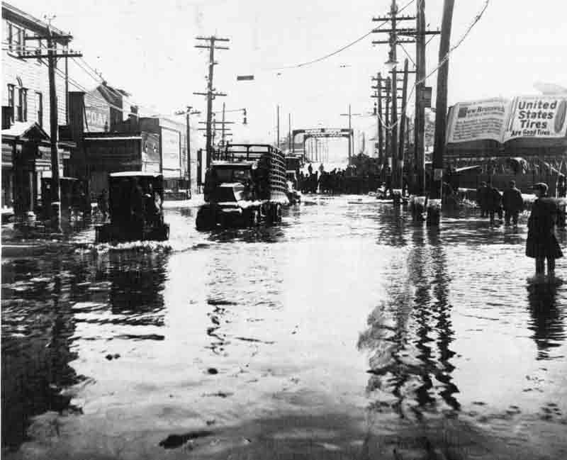
The 1920s photo of flooding on Albany Street seems eerily familiar.
Down in North Brunswick crowds turned out to watch them dig out what became Georges Road.

On the banks of the old Lawrence Brook, not far from the mighty Raritan River.

28 October 2012
15 November 2011
Along the Raritan
We've been following news about the Raritan River all semester, and you never know what the next story will be. But I was still surprised by seeing the Home News and Tribune report that "an inert bomb was discovered on Oct. 13 during a parking lot excavation at a distribution center for the AriZona Beverage Co. in Raritan Center." The Raritan Center are is the site of the army's old Nixon Nitration Works, so maybe it shouldn't be a as much of a surprise. But a bomb is still a shocker, even in times of war.
08 November 2011
Touch the water
A report on river access points on the Banks of the Old Raritan shows lots of opportunities, but they are well hidden and sometimes not easy to use.
20 September 2011
Raritan River Festival
If communities are going to start treating the Raritan River better, one of the first steps will be to get people back in touch with the river.
26 August 2011
Mapping out Hurricane Irene
ESRI has created an online map of storm data as well as a list of links to other resources to help you track Hurricane Irene in all of its gory details. StormPulse has its own online app that is pretty amazing. Here in New Jersey you'll want to watch the online river gages, like this one at Keansburg, especially to see if they stay online:

Stay dry.

Stay dry.
27 June 2011
A Dismal Swamp story
The Home News and Tribune has rediscovered the Dismal Swamp and the people trying to protect it.
Subscribe to:
Posts (Atom)


