17 March 2018

eGov - Washington County, OR

I was digging around for some materials to use in class this weekend and found myself back at an old favorite website. It was the official site for Washington County, Oregon. Nearly 20 years after first visiting them, I found the site to still be one of the best examples of local government online. It has both user friendly and detailed materials, allowing visitors to pick what they need.

Just as an example, it presents GIS-related materials as:
  • carefully developed cartographic products (maps),
  • interactive online maps and materials, and
  • downloadable GIS data.
 Dig around, check it out. (Or dig around in Independence, MO, another fascinating example)

09 March 2018

Puerto Rican forest damage map

The NY Times took a fascinating look at research in PR that is investigating the nature and extent of Hurricane Maria's damage to the island's forests. The article includes an amazing map from Columbia U that shows where the damage occurred. In the east is cluster of high damage in El Yunque National Forest. But there is widespread damage all over. The research estimates that as many as 31 million trees were destroyed or severely damaged.

There is more than just the great map. The article goes into detail about how the researchers are ground truthing Landsat imagery to better understand their data. And they begin to speculate on what long-term changes might look like in that forest.


08 March 2018

More Census details

A Rutgers Ph.D. student got a piece published on Huffington Post that says "Black Latinos Are Almost Invisible In The Census. We Can Fix That."

She builds both on her doctoral research project as well as personal experiences. The pull quote of the article is:
"Latino is not a race, it is an ethnicity. Ethnicity describes a person’s culture, language, heritage and geography. Race, on the other hand, is about how others see us. And although most social scientists agree that race is a social construct, they also contend that it does matter; our experiences are undeniably shaped by our race."
 How many more questions have this sort of complexity built into them?

05 March 2018

Geodesign in the news


Forbes has posted a feature on Geodesign today. It is an interesting indicator of how broadly the topic appeals to the general public and the private sector. The examples, while short, demonstrate variety in Geodesign as they range from utility networks, to Chinese sponge cities, to German Autobahn.


01 March 2018

Census update

As a update to an earlier post about the US Census:


25 February 2018

Slope Maps

Here is a basic slope map.
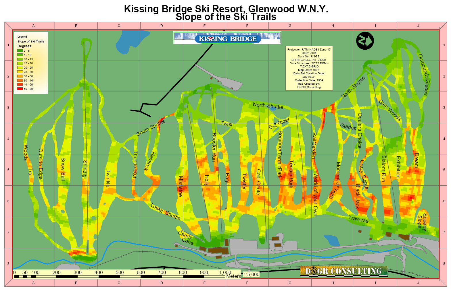
If you discard much of the information, you might get something like this one of some ski slopes.
Since a slope map doesn't show much by itself, here is a way to combine it with something else.

21 February 2018

Closing the Gateway?

The Gateway Project has been seen as possibly the single most important transportation project in the US. But a recent Federal Transit Administration review scored it lower than expected. Coupled with the new administration's Infrastructure Plan, it has people wondering how the project will move forward. It also has some questioning the scoring process:

"In case it wasn't clear before, President Trump today tried to land another death blow to Gateway, by having his Federal Transit Administration vindictively and inexplicably downgrade the project in order to cut off critical federal funding," said U.S. Sen. Robert Menendez (D-N.J.) in a press release.
PlaNetizen offers a pretty good overview of the current situation.  Railway Age writes that the rating of Medium-Low is the second worst possible on the FTA scale and threatens the ability of the 2 neighboring states to get the necessary loans.

13 February 2018

2020 Census woes

The Washington Post recently ran a headline that said The 2020 Census is in deep trouble. And, explained the opinion piece, the stakes could be high:
It is already woefully underfunded, understaffed, underappreciated and behind schedule. But it will determine, in a major way, the future of our political parties, if not our democracy.
The nominee to run the 2020 Census has just been withdrawn.

Recently, more than 160 mayors sent a letter to Commerce Secretary Wilbur Ross confronting him with the realities of the situation. Citylab reports that the letter raises serious concerns while pointing out that the census is a constitutionally mandated activity that has been proudly undertaken since 1790. Of course, in the dynamic landscape of this administration, there are questions regarding whether Ross will still be around in 2020.

If we wait long, it will simply be too late to fix it. It takes years for Bureau to staff up and build the necessary infrastructure for the decennial census. What can be done? Should states intervene? Or will lawsuits by groups like the NAACP help?  Keep watching.

(In the meantime, explore TIGERweb)

12 February 2018

Lincoln memorials

Vox is celebrating Lincoln's birthday by posting images of many of the failed proposals for the Lincoln Memorial. Had they built Pope's memorial on Meridian Hill, the whole city would be different.

"To hold its own with this monument, a Lincoln Memorial first must possess this vital quality of bigness and of dignity." - John Russell Pope

Architecture of the Olympics

ArchDaily posted a nice introduction to the $100 million stadium that will only be used 4 times. (mapped)

06 February 2018

Mayan LiDAR application

LiDAR is already established as an incredibly useful tool. But National Geographic shows a new application for it. In a remote jungle in Guatemala, LiDAR helped produce a detailed map of an ancient civilization. Jumping past the details, one researcher described the project's impact this way:
“After decades of combing through the forests, no archaeologists had stumbled across these sites. More importantly, we never had the big picture that this data set gives us. It really pulls back the veil and helps us see the civilization as the ancient Maya saw it.”
 Be sure to click over and look at the imagery. Really amazing stuff.

02 February 2018

Mapping the toxic landscape

There are lots of tools out there to help map out the Toxic Release Inventory, but here are a few favorites:


01 February 2018

Park promotion profile

Our Common Lecturer this week, Claire Agre of West 8, mentioned that New Yorker ran a piece on their founder, Adriaan Gueze. While the 2016 piece focuses on NYC's Governor's Island, it expands to a great profile of the dutch designer.

The article closes with some great quotes that sum up the spirit of West 8's approach:

It isn’t just children who need opportunities to run free. New York Harbor offered Geuze a grand borrowed landscape, and a ferry ride that sets this park off from all the others in the city. “There’s no doubt that mass culture has a hundred-per-cent success in making the world programmed,” he told me. “Everything is branded, everything has a name, has a function that you have paid for. That makes a very relevant question for our generation of designers. If we are interfering in public space, should we be part of that, or should we offer a sort of antidote?” His answer, in this spot, is clear: “Maybe we should make an environment where everyone can enjoy the lightness, and you can play.”
Go back and read.