The Subway is Not Scary is an essay from Hamilton Nolan. If you are one of those people who avoids the subway in NYC, give him a hance to convince you that you should ride it more. I find it to be a pretty amazing system and, as he suggests, don't understand why some work so hard to avoid it.
Showing posts with label Transportation. Show all posts
Showing posts with label Transportation. Show all posts
23 June 2025


14 February 2024
Preventable auto accident deaths
The planning community has lots of ongoing conversations about improving road safety (including how to reduce our reliance on this dangerous infrastructure). But it is worth taking note when a more public outlet notices. This week, I was struck by the way that Vox wrote about the plague of fatal accidents in the Global South. But notice that they mention that the US is another hotspot too.
25 July 2020
02 March 2020
Colombian commuting
Commuting is fascinating and complex and dreadful. Commuting in Colombia is especially complicated as they have 3 rush hours. A new piece at CityLab provides fascinating maps of Medellin commuting patterns that illustrate a financial disparity in commuters: "The researchers also found that commuting time decreases as
socioeconomic class increases, due not only to smaller distances but
also more efficient modes of transportation."

As someone studying access to treatment in Colombia, this is another reminder of how much travel time shapes the ultimate outcomes of access. For those with limited mobility, this would be especially true.

As someone studying access to treatment in Colombia, this is another reminder of how much travel time shapes the ultimate outcomes of access. For those with limited mobility, this would be especially true.
09 September 2019
31 July 2019
Breezewood
CityLab posted a piece by Amanda Kolson Hurley that presents a little extra background on the famous Burtinsky photo of Breezewood. She tries to argue that Breezewood, PA is a remarkably unique place. In a sense I agree, since places are all unique. The specifics of the development, the adjacent hill, But I disagree in that the famous photo of Breezewood really captures a sense of place that is not unique (see US 11 just a few miles away in Carlisle, PA). You don't have to agree completely to enjoy this piece.
28 April 2019
We have a winner!
StreetsBlog USA has chosen a winner in its competition to find the 2019 Parking Madness Champion. The finals came down to 2 cities that each did their best to fill (or replace) a parking crater with a real use of the land. You will have to read their explanation to see who won.
07 May 2018
Another sign of summer
Interchanges is back, providing a daily dose of Interstate highway engineering and design.


All photography generously paid for by the USDA National Agricultural Imagery Program.


All photography generously paid for by the USDA National Agricultural Imagery Program.
22 February 2018
21 February 2018
Closing the Gateway?
The Gateway Project has been seen as possibly the single most important transportation project in the US. But a recent Federal Transit Administration review scored it lower than expected. Coupled with the new administration's Infrastructure Plan, it has people wondering how the project will move forward. It also has some questioning the scoring process:
PlaNetizen offers a pretty good overview of the current situation. Railway Age writes that the rating of Medium-Low is the second worst possible on the FTA scale and threatens the ability of the 2 neighboring states to get the necessary loans.
"In case it wasn't clear before, President Trump today tried to land another death blow to Gateway, by having his Federal Transit Administration vindictively and inexplicably downgrade the project in order to cut off critical federal funding," said U.S. Sen. Robert Menendez (D-N.J.) in a press release.
23 January 2018
Maps as art
If your GIS assignments are looking a little dull, maybe Topi can help inspire you to achieve something more creative.
Topi Tjukanov is a Helsinki-based GIS/Cartographer who does amazing things with public data. His gallery online includes an elegant map of the optimal route from the geographic center of the US to every county in the US. Another map he created illustrates the differences between driving, biking, and walking to the outer edges in his hometown.
Topi Tjukanov is a Helsinki-based GIS/Cartographer who does amazing things with public data. His gallery online includes an elegant map of the optimal route from the geographic center of the US to every county in the US. Another map he created illustrates the differences between driving, biking, and walking to the outer edges in his hometown.
18 January 2018
Traffic fatalities
Curbed reports on a study that found that the US has unusually high rates of traffic fatalities compared to peer nations.
“The United States is one of the richest countries in the world, yet we have a very poor record of road safety,” says Welle. “The U.S. has nearly triple the fatalities of countries like Sweden or the Netherlands.”
The article points out that some states have already taken steps towards these International standards. By contrast, others seem to promote danger:
Remember, these are not accidents, they are fatalities. It is a matter of health and safety, not just convenience.“If you go on city streets, especially in the U.S. suburbs, these roads are what people call dangerous by design,” she says. “And often, the level of forgiveness of speeding here, of allowing people to go 10 miles over the limit, can mean the difference between survival and death.”
23 May 2017
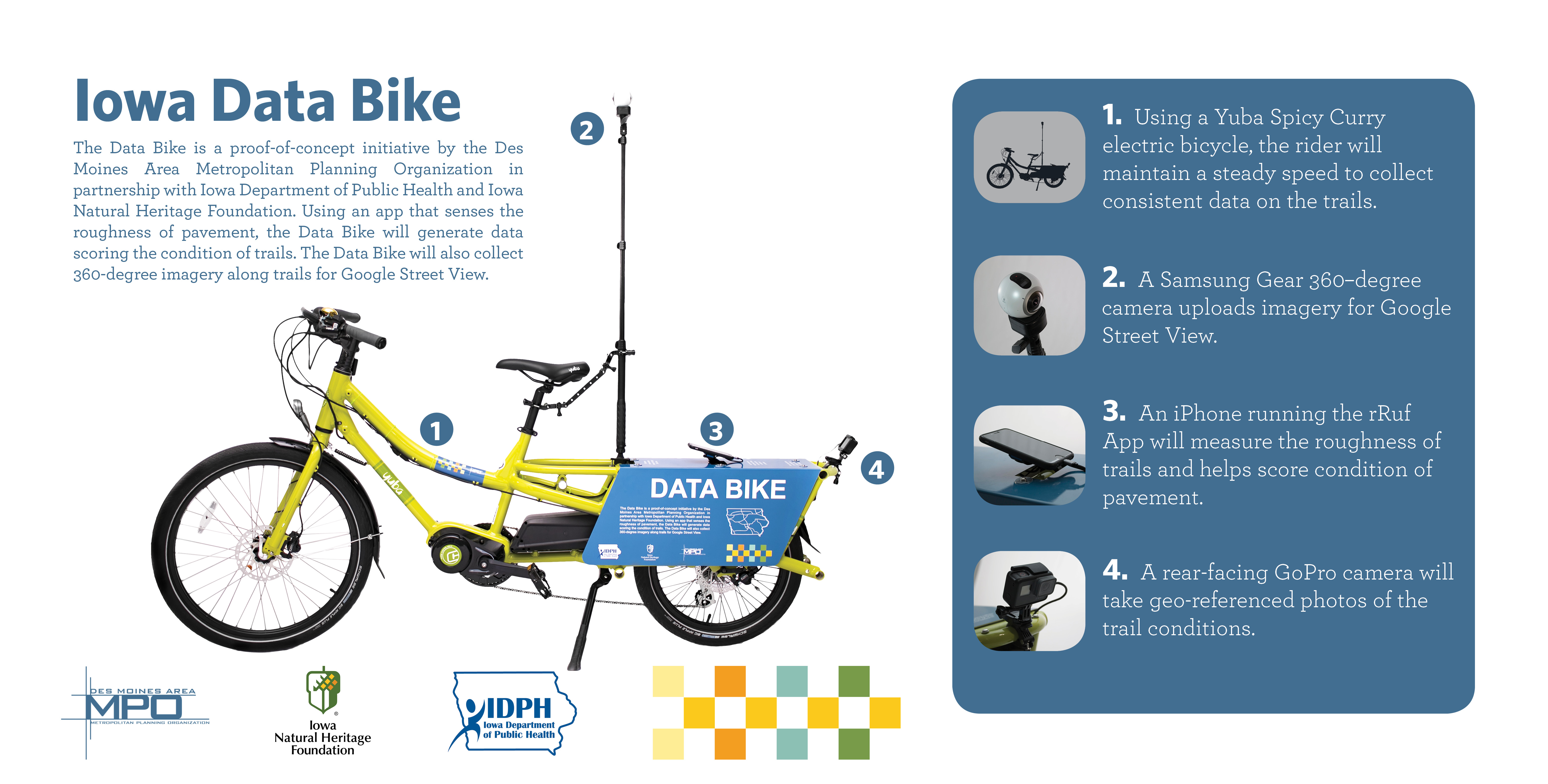
Iowa Data Bike
In GIS we know about data banks. But maybe it is time get to know the data bike. It will help collect data and even images that can be posted on Google Street View.
21 November 2016
25 October 2016
Money for Karst windows
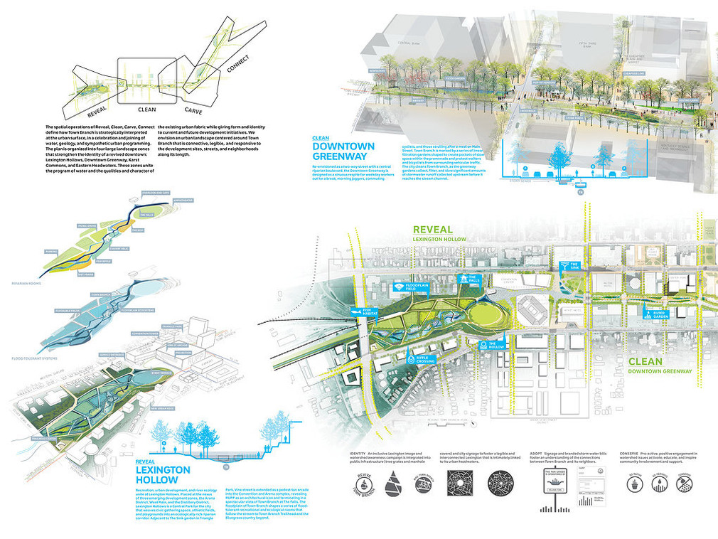
The Architects Newspaper reports that SCAPE has gotten significant support for their Town Branch plan for Lexington. The support comes in the form of a $14.1 million grant from the US Department of Transportation. The project is helping daylight the long-hidden and often ignored Town Branch with a strip of park called Karst Commons and special Karst Windows celebrating the local geology.

05 July 2016
Good news for Barcelona
The City of Barcelona is banning Segways from the central portions of the city. They are considered part of the class of transportation that could be called "novelty urban transit". Like duck rides in Boston or beerbikes in Amsterdam, they ensure that tourists have a visible impact on the city they visit. In a cultural setting they are the equivalent of poor ecotourism.
Writing on The Atlantic CityLab Feargus O'Sullivan says, " It would surely be going too far to damn Segways as Satan’s chariots, but they still need to go. Barcelona’s waterfront should be an open-air living room for the city, not a place where the experience of the city is simulated for motorized, walkway-clogging tourist groups."
Writing on The Atlantic CityLab Feargus O'Sullivan says, " It would surely be going too far to damn Segways as Satan’s chariots, but they still need to go. Barcelona’s waterfront should be an open-air living room for the city, not a place where the experience of the city is simulated for motorized, walkway-clogging tourist groups."
22 April 2016
An Earth Day treat
New York City is celebrating Earth Day with car-free zones. Follow #CarFreeNYC as it happens.
BTW, Sunday is Ciclovia in New Brunswick, which is pretty similar.
BTW, Sunday is Ciclovia in New Brunswick, which is pretty similar.
30 March 2016
Tunnel
Environmental planning builds on infrastructure that reinforces its efforts. Improving commuting in the NYC Metro area is key to keeping cars off the roads and making communities more livable. CBS says that the Gateway project could do that for Ridgewood.
17 February 2016
Access to care
This story from Baltimore highlights how access to healthcare remains a key issue in understanding the health landscape.
The doctor told Sharlene Adams to get a blood pressure cuff, so Adams set out to buy one.
For Adams, who lives in West Baltimore, that meant four bus rides, a stop for a doctor’s signature, two visits to a downtown pharmacy for other medical supplies, a detour to borrow money for a copay, a delay when a bus broke down, and, at last, a purchase at a pharmacy on the east side of town.
The one-way, 7-mile trip took 5 1/2 hours. Then she had to get back home.
20 January 2016
Transit planning that works like a videogame?
Governing magazine reports on a new software app called Remix that empowers transit planners. They quote Joshua Poe, a planner in Louisville, as saying,
"Transit planners have been lacking a long time in anyone building
software with us in mind in terms of our daily needs." The tool really looks like the sort of spatially-enabled information-laden app that is usually talked about at the Geodesign Summit.
Subscribe to:
Posts (Atom)