
04 May 2019
Louisiana storm surge maps
The new interactive storm surge risk maps recently released by the National Hurricane Center show a Category 5 hurricane could push at least 9 feet of water into Baton Rouge. But I am more worried about the rapidly growing areas Ascension Parish which get wet in even the mildest scenarios.


02 May 2019
Foxconn designs vs. deliverables
The story of Wisconsin's recruitment of Foxconn to Racine County is complicated and incomplete. It includes a CEO running for president of Taiwan and President with his own history of eminent domain abuse. I won't try to explain it all here, but the WSJ has a new look this week. It includes some threats of eminent domain abuse:
 Reply All recorded an episode of their podcast on the project.
A local paper reports that the really futuristic stuff is still coming, next year.
But The Verge looks at this asking how anyone is taking these seriously:
"The village bought hundreds of pieces of property, holding out the possibility of enforcing eminent domain. It worked out deals with Racine County, the water authority and the power company to bring services to the site. The state legislature agreed to bypass some permitting processes, letting Foxconn fill wetlands without getting an environmental-impact statement. The state received a $160 million federal grant to help expand Interstate 94 a decade ahead of schedule."One of the other issues is where the water for the project will come from. Urban Milwaukee asks whether the plant merits permission for a water diversion, as it straddles the line between the Mississippi and Great Lakes Basins.
A local paper reports that the really futuristic stuff is still coming, next year.
But The Verge looks at this asking how anyone is taking these seriously:
"The secrecy and vagueness are frustrating to critics. How do you prove that Foxconn won’t build an enormous LCD factory during an industry glut or create a research campus larger than MIT in rural Wisconsin other than by pointing out that experts — and even, occasionally, Foxconn executives — say it makes no sense?"But to really understand the sales pitch, you have to see the designs that were proposed for the Wisconn Valley properties. Racine County has shared this video which captures the vision. And it raises the frequent concerns about the difference between the sci-fi representations and buildable realities.
30 April 2019
Prescription Parks
As we wrap up National Landscape Architecture Month, I am excited to see that the prescription parks movement is getting new attention, especially with some mapping of the parks in and around Washington DC. ASLA's The Dirt returns to this topic to capture how it continues to grow and offers some new details. The integration of the medical community and the use of the phone app make this old idea seem new again. And for landscape architecture, it just reemphasizes the important role that we can have in improving health in our communities.

29 April 2019
GIS Job in Colorado
The Department of Geography and Environmental Studies (GES) at
the University of Colorado Colorado Springs (UCCS) invites applications for a
full-time, 12-month geospatial technologies specialist to begin July 1,
2019. Responsibilities include 1) teaching 12 credit hours of
introductory-level geospatial courses per year, 2) maintaining GES
servers, the GES geospatial laboratory, and the GIS classroom to support
the technology required for the delivery of courses, 3) managing online /
cloud-based geospatial software accounts and live server connections, 4)
managing GIS mapping and spatial data analysis platforms, 5) managing
interactive online teaching and learning activities between users, 6) working
collaboratively with university IT staff to ensure software environments are
updated and hardware peripherals function, 7) supporting the GES GIS
Certificate Program, and 8) supporting faculty and students with research,
applied projects, and individualized instruction.
Requirements for all applicants are 1) a minimum of two years of
professional experience configuring, maintaining, and administering ArcGIS
Server and SQL Server, 2) a minimum of two years of professional experience
providing day-to-day functioning and oversight of a professional or academic
GIS program, 3) a plan to develop strategies that would contribute to the
department, college, and campus mission, 4) experience teaching a minimum of
one course in introductory-level geospatial technology equivalent to GES 2050 -
Digital Earth and GES 3030 - Introduction to GIS as instructor of record and/or
as teaching assistant, and 5) a Master’s degree in geography, GIScience or
related geospatial field conferred by July 1, 2019. The University of Colorado
offers a comprehensive benefits package. Information on benefits programs can
be found at: https://www.cu.edu/employee-services/benefits.
Salary Range: $60,000 to $64,000
Applications received by May 1, 2019 will receive full
consideration. Applications submitted through email or surface mail are not
considered. Contact Dr. Diep Dao (tdao@uccs.edu)
or Dr. Brandon Vogt (bvogt@uccs.edu) with
questions.
Submit a cover letter, resume/cv, unofficial transcripts, and
contact information for five references to: https://cu.taleo.net/careersection/2/jobdetail.ftl?job=16032&lang=en&sns_id=mailto#.XJ7azP8yb4k.mailto
28 April 2019
We have a winner!
StreetsBlog USA has chosen a winner in its competition to find the 2019 Parking Madness Champion. The finals came down to 2 cities that each did their best to fill (or replace) a parking crater with a real use of the land. You will have to read their explanation to see who won.
18 April 2019
17 April 2019


13 April 2019
GIS Summer job
Philmont Scout Ranch in Cimarron NM is looking for a summer
Conservation GIS Coordinator. Dates are flexible, mid May through
August. Great position for a Bachelor or Grad student with experience in
Esri’s ArcGIS Technologies who enjoys the outdoors.
Job description found at https://20lisa1ukask2skqr737a50o-wpengine.netdna-ssl.com/wp-content/uploads/filestore/pdf/jobs/Conservation_GIS_Coordinator_HW.pdf.
For questions about this position and other Philmont Scout
Ranch conservation job opportunities, contact: John Celley Recreation Resource
Manager Philmont Scout Ranch john.celley@scouting.org
(575) 376-2281 x1249
11 April 2019
Leveraging GeoHealth for Global Surgery
I am presenting today at Global Surgery Colombia and wanted to share some of what we are hearing.
In the opening address by Walter Johnson of the World Health Organization (UN) we learned about the complexity of WHO's approach to global health issues. I was struck by the diagram he used to diagram the financing:

It is impressive for its elegance as an infographic. But more importantly, it convincingly makes that point. Global health is vast and complex.
Surgery is increasingly important in the global health equation because of the alarming rate of global growth of non-communicable disease.
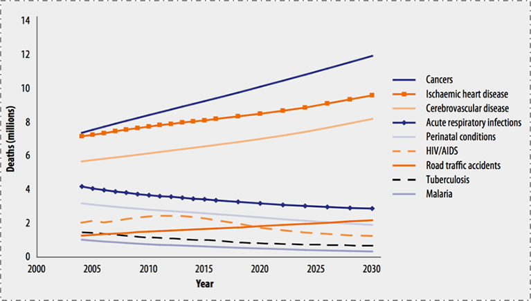 The turn towards surgery is challenging, because it requires more than just shipping supplies to remote areas. It requires infrastructure. It requires skilled specialists. It requires coordination.
Gabriel Herrera MD FACS helped explain the Lancet Commission's 6 indicators as a foundation for examining the surgical system for an entire country. Having worked on the topic for much of the last year, it was remarkable to hear it presented to an audience of surgeons and medical students.
But the highlight of the morning came when the Vice Minister of Health, Dr. Ivan Dario Gonzalez, announced that there will soon be a public online map of all of the hospitals in Colombia. Having mapped Colombian hospitals some myself, it was exciting to see the points arrayed on the map and to hear of the commitment to push these data into the public realm as an explicit step to improve health across the country.
In the opening address by Walter Johnson of the World Health Organization (UN) we learned about the complexity of WHO's approach to global health issues. I was struck by the diagram he used to diagram the financing:
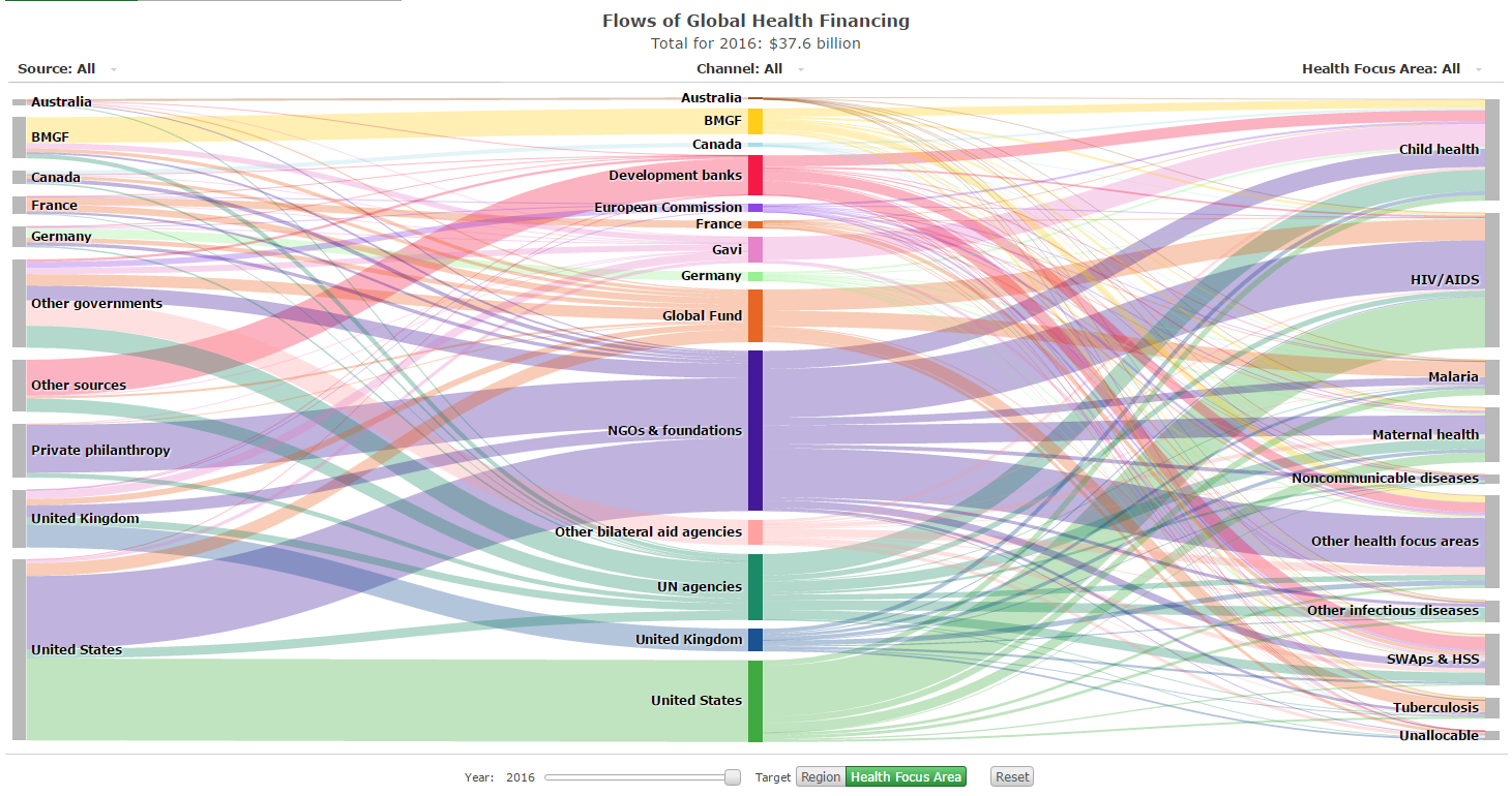
It is impressive for its elegance as an infographic. But more importantly, it convincingly makes that point. Global health is vast and complex.
Surgery is increasingly important in the global health equation because of the alarming rate of global growth of non-communicable disease.
Gabriel Herrera MD FACS helped explain the Lancet Commission's 6 indicators as a foundation for examining the surgical system for an entire country. Having worked on the topic for much of the last year, it was remarkable to hear it presented to an audience of surgeons and medical students.
But the highlight of the morning came when the Vice Minister of Health, Dr. Ivan Dario Gonzalez, announced that there will soon be a public online map of all of the hospitals in Colombia. Having mapped Colombian hospitals some myself, it was exciting to see the points arrayed on the map and to hear of the commitment to push these data into the public realm as an explicit step to improve health across the country.
03 April 2019
The Original Pinelands Comprehensive Plan of 1980
I was pretty excited when I found out that both parts of the original 1980 New Jersey Pinelands Comprehensive Management Plan are available online.


Subscribe to:
Posts (Atom)


