29 April 2019

GIS Job in Colorado

The Department of Geography and Environmental Studies (GES) at the University of Colorado Colorado Springs (UCCS) invites applications for a full-time, 12-month geospatial technologies specialist to begin July 1, 2019.  Responsibilities include 1) teaching 12 credit hours of introductory-level geospatial courses per year, 2) maintaining GES servers,  the GES geospatial laboratory, and the GIS classroom to support the technology required for the delivery of courses, 3) managing online / cloud-based geospatial software accounts and live server connections, 4) managing GIS mapping and spatial data analysis platforms, 5) managing interactive online teaching and learning activities between users, 6) working collaboratively with university IT staff to ensure software environments are updated and hardware peripherals function, 7) supporting the GES GIS Certificate Program, and 8) supporting faculty and students with research, applied projects, and individualized instruction. 

Requirements for all applicants are 1) a minimum of two years of professional experience configuring, maintaining, and administering ArcGIS Server and SQL Server, 2) a minimum of two years of professional experience providing day-to-day functioning and oversight of a professional or academic GIS program, 3) a plan to develop strategies that would contribute to the department, college, and campus mission, 4) experience teaching a minimum of one course in introductory-level geospatial technology equivalent to GES 2050 - Digital Earth and GES 3030 - Introduction to GIS as instructor of record and/or as teaching assistant, and 5) a Master’s degree in geography, GIScience or related geospatial field conferred by July 1, 2019. The University of Colorado offers a comprehensive benefits package. Information on benefits programs can be found at: https://www.cu.edu/employee-services/benefits.

Salary Range:  $60,000 to $64,000

Applications received by May 1, 2019 will receive full consideration. Applications submitted through email or surface mail are not considered. Contact Dr. Diep Dao (tdao@uccs.edu) or Dr. Brandon Vogt (bvogt@uccs.edu) with questions.

Submit a cover letter, resume/cv, unofficial transcripts, and contact information for five references to: https://cu.taleo.net/careersection/2/jobdetail.ftl?job=16032&lang=en&sns_id=mailto#.XJ7azP8yb4k.mailto

28 April 2019

We have a winner!

StreetsBlog USA has chosen a winner in its competition to find the 2019 Parking Madness Champion. The finals came down to 2 cities that each did their best to fill (or replace) a parking crater with a real use of the land. You will have to read their explanation to see who won.


13 April 2019

GIS Summer job


Philmont Scout Ranch in Cimarron NM is looking for a summer Conservation GIS Coordinator.  Dates are flexible, mid May through August.  Great position for a Bachelor or Grad student with experience in Esri’s ArcGIS Technologies who enjoys the outdoors.  

For questions about this position and other Philmont Scout Ranch conservation job opportunities, contact: John Celley Recreation Resource Manager Philmont Scout Ranch john.celley@scouting.org (575) 376-2281 x1249

11 April 2019

Leveraging GeoHealth for Global Surgery

I am presenting today at Global Surgery Colombia and wanted to share some of what we are hearing.

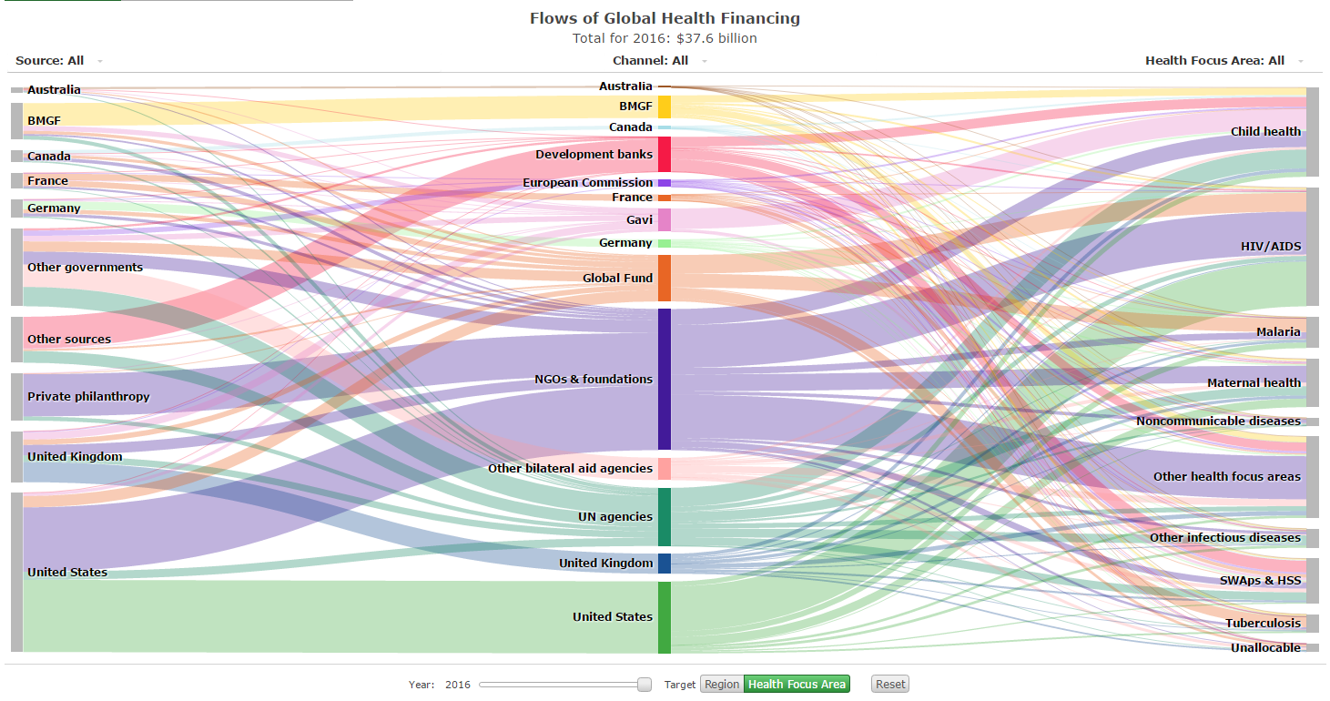
In the opening address by Walter Johnson of the World Health Organization (UN) we learned about the complexity of WHO's approach to global health issues. I was struck by the diagram he used to diagram the financing:


It is impressive for its elegance as an infographic. But more importantly, it convincingly makes that point. Global health is vast and complex.

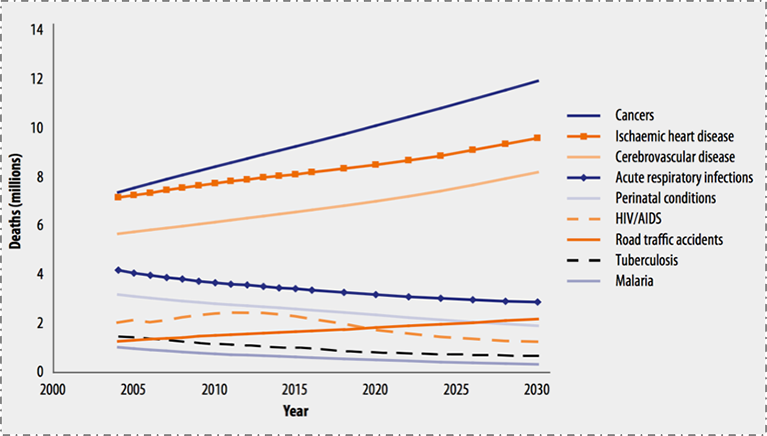
Surgery is increasingly important in the global health equation because of the alarming rate of global growth of non-communicable disease.


The turn towards surgery is challenging, because it requires more than just shipping supplies to remote areas. It requires infrastructure. It requires skilled specialists. It requires coordination.


Gabriel Herrera MD FACS helped explain the Lancet Commission's 6 indicators as a foundation for examining the surgical system for an entire country. Having worked on the topic for much of the last year, it was remarkable to hear it presented to an audience of surgeons and medical students.

But the highlight of the morning came when the Vice Minister of Health, Dr. Ivan Dario Gonzalez, announced that there will soon be a public online map of all of the hospitals in Colombia. Having mapped Colombian hospitals some myself, it was exciting to see the points arrayed on the map and to hear of the commitment to push these data into the public realm as an explicit step to improve health across the country.

02 April 2019

Are planned cities good?

While planned cities like Washington DC and Savannah provide interesting examples of landscape plans for entire cities, Brasilia is often treated as a prime example of why these might be a good idea. This post, Uneven Development of Planned Cities: Brasilia, by Jordi Sanchez-Cuenca explains one concern.


31 March 2019

Beatrix Farrand documentary

CORRECTION: On Wednesday at 7 join us for a visit from Karyl Evans as we learn about her documentary on Beatrix Farrand.

This is the first documentary ever produced about the life and gardens of Beatrix Farrand, the most successful female landscape architect in early 20th century America and one of the founders of the American Society of Landscape Architects.


This compelling film chronicles the life of Beatrix Farrand (1872-1959), the niece of Edith Wharton, who grew up in the privileged world of the East Coast elite and fought through the challenges of working in a male-dominated profession to design over 200 landscape commissions during her remarkable 50-year career.
The documentary takes viewers on an inspiring journey across the country as we explore her personal story and many of her most spectacular gardens, including Dumbarton Oaks in Washington, D.C.; the Peggy Rockefeller Rose Garden at the New York Botanical Garden; Garland Farm in Bar Harbor, Maine; the Abby Aldrich Rockefeller Garden in Bar Harbor, Maine; and her California gardens.


The narrative is recounted through interviews with Farrand scholar Diana Balmori, landscape historian Judith Tankard, and landscape architect Shavaun Towers. Current photographs and footage of more than 50 Farrand-related sites along with archival images from the Beatrix Farrand Archives at the University of California Berkeley are woven together to bring to life Beatrix Farrand’s extraordinary story, reminding us why her awe-inspiring work is still relevant to this day.

Karyl Evans is a six-time Emmy Award-winning documentary filmmaker. Ms. Evans, owner of Karyl Evans Productions LLC in North Haven, Connecticut has produced more than 50 historical documentary projects over her 30 year career. Karyl is on the National Speakers List for the Garden Club of America and is a Fellow at Yale University.

To learn more about the work of Karyl Evans visit: KarylEvansProductions.com 

28 March 2019

Forked River Mountains

The latest The State We Are In column introduces many readers to the Forked River Mountains of the Pinelands. Well worth a read, especially as spring fever sets in. You will surely want to take a trip down to explore some section of the Pinelands, if not this one.


27 March 2019

New Brunswick Memories

The Library of Congress kept a collection online called American Memory. Within that there are some great New Brunswick resources. Here is a sample...

A 1936 photo near the tracks

The Indian Queen Tavern

 A D&R Canal lock


05 March 2019

NJ GeoWeb

As a quick study tool, try exploring NJ GeoWeb.

Start out trying something simple, like overlaying schools on land use.

But then try something harder. Can you make a custom digital map of superfund sites within 100’ of all streams in Middlesex County, NJ, overlaid on a backdrop showing the county’s soils?

28 February 2019

Social Explorer

While you are on campus, you can access https://www.socialexplorer.com/ through a guest account that lets you make demographic maps. The map below shows where municipal government employees are.


26 February 2019

Story maps

One of the more interesting aspects of ArcGIS is the way that the platform supports Story Maps. These are story-telling mechanisms that feature interactive maps as their backbone.

The Out of Eden Walk Milestones Story Map uses a map to capture an amazing journey, but also integrates prose and photography and HD video along the way.

Save a trip to Florida and explore the public art on the campus of USF.

The Sounds of the Wild West Story Map integrates audio in ways that transport you.

The Library of Congress has created an amazing historic exploration called Camera and Locomotive: Two Tracks Across the Continent. Loaded with content, it is more like an online museum exhibit than it is a web page.


There are environmental planning story maps, like this one on NYC Hazard Environment.

And, closer to home, check out the Susan Edmund's Mill Brook: Portrait of an Urban Stream.


18 February 2019

NJ GeoWeb

Looking for 1930s aerial photography of NJ or need a way to overlay municipal boundaries with the NJ DEP Known Contaminated Sites List? You should try the NJ Geoweb app. But you can do more sophisticated spatial searches, too. It would let you find all of the schools in Morris County that are within 1200 feet of a Dry Cleaner. 


Monday's Map


h/t Mapscaping

16 February 2019

Web Soil Survey

Take a few minutes and explore a familiar site in the NRCS Web Soil Survey. Here is one I made while exploring a section of the park at Gettysburg.


Also, for fun, check out the 1925 Bergen Area Soil Survey.


06 February 2019

NJ Topo Maps at Rutgers

Some different scenes from around New Jersey as depicted in USGS Topographic Quad Maps. Just click and they'll expand.


A special thanks goes out to Mike Siegel and the Rutgers Cartography Lab.  This is a great resource for students and for pros.

04 February 2019

01 February 2019

31 January 2019

27 January 2019

Top 10 issues for the Lower Raritan

At Rutgers, we famously sit "on the banks of the Old Raritan." So it has been great watching the university become increasingly interested in the river over the past decade.

A great place to start is this list of the Top 10 Environmental Problems facing the Lower Raritan Watershed in 2019. The list is written by Heather Fenyk, President of the Lower Raritan Watershed Partnership. Her list is great because it integrates scientific issues like biodiversity with institutional issues like the inability to develop a regional planning framework.

24 January 2019

the food state we're in

Michele Byers writes a regular column, published in a variety of New Jersey papers, called The State We're In. Foodies will find her latest column interesting as it links regenerative agriculture with other topics including climate change and human health.

22 January 2019

True costs of online mapping?

In a piece on The Medium, Jason Voiovich asks whether the utility of Google Maps is worth the hidden costs. Google long ago moved past being a search company and is now an information broker. But his reminder of how much of that information we provide was a good read at the start of the semester.


09 January 2019

The power of where?

Shimonti Paul writes in "Maps define ‘The Power of Where’" about myriad ways that GIS and maps are serving people, ranging from basic public uses to advanced applications for emergencies. You can use a red flag to mark the spot where they call it utopian, but the piece has some nice quotes that make it worth a read.


04 January 2019

Use at your own risk?

National Parks have always been a little dangerous. That is part of their appeal. But, while the park rangers are furloughed, some people are still using National Parks. And, explains the Washington Post, for at least three different visitors it has turned deadly.


“A casual cross country skier would want to go to Tower Falls” in Yellowstone, Wenk said. “If they suffer a heart attack — every year you have that — we wouldn’t be able to quickly respond. You might be dramatically delayed. It’s correct, people die in national parks all the time. If you can attribute [the shutdown] to people not being able to get to them for an hour and a half, that’s another story.”

31 December 2018

The intersection of art and the Lower Raritan

TaeHo Lee has posted a great interview with artist, Olga Bautista. Her work exploring natural materials and trash, will be displayed later in January at Kim's Bike Shop. I am looking forward to seeing the work because it sounds like she has found a way to connect personal or intimate interactions with plants and streams, with larger expressions about the forces nature.


The opening reception for Windows of Understanding is at the Zimmerli Art Museum on January 22nd. Olga’s art installation will be exhibited at Kim’s Bike Shop, 111 French St., starting on January 21st. From 10-noon on January 21 the Olga and the LRWP will participate in walking tours of the art installations and seed plantings at 10am and 2pm.