16 December 2014
Crime and trees
Since at least 2001, when Kuo and Sullivan wrote about trees in urban housing developments in Chicago, it has been clear that trees and crime are related. But later studies have muddied the waters a bit. Recent studies in Baltimore have clarified things a bit more and CityLab has posted a summary that reduces the relationship between crime and trees down to basics, like: "While low dense brush seems to increase it, tall broad canopies seem to decrease it."
15 December 2014
Top 10 books of 2014
PlaNetizen has released its list of the Top 10 books of 2014. It is a great source of ideas for reading over the break.
12 December 2014
Crowdsourcing for Open Government
Is crowdsourcing just a fad or is it something that is getting built into an increasing array of activities? This post from WhiteHouse.gov provides evidence of the latter. The post lists several major projects within the Federal government that leverage volunteerism. They cover weather and nature, but also include a link to an effort I had previously overlooked at the National Archives.
11 December 2014
Cooper Hewitt
The Cooper Hewitt is about to reopen and it looks amazing. It would be a great trip during the break.
09 December 2014
"2014 From Above"
Has remote sensing gone mainstream? Slate has posted a feature on the top satellite photos of the year. Seems like a strong indication that the technology has become widely accepted and understood.
A geodesign dissertation
How many geodesign dissertations have been completed? I don't have an answer. But I can account for at least one.
Former Arizona State University student, Melinda Shimizu, has completed a dissertation titled, The Development and Assessment of A Spatial Decision Support System for Watershed Management in the Niantic River Watershed: A Geodesign Approach. It is exciting to see the ideas of geodesign getting tested. When I hear concerns raised, it is good to know that some are trying to reduce the uncertainty in the field by creating this foundation of literature.
Former Arizona State University student, Melinda Shimizu, has completed a dissertation titled, The Development and Assessment of A Spatial Decision Support System for Watershed Management in the Niantic River Watershed: A Geodesign Approach. It is exciting to see the ideas of geodesign getting tested. When I hear concerns raised, it is good to know that some are trying to reduce the uncertainty in the field by creating this foundation of literature.
08 December 2014
The Hub
Changes are coming to New Brunswick. The replacement for the old Penn Plaza is a towering development called the The Hub. New York YIMBY blog has posted renderings of the new development which will dramatically change the area across from New Brunswick's Penn Station.
What do you think?
What do you think?
04 December 2014
Essays on Geography and GIS
Esri has released its latest online issue of Essays on Geography and GIS. For fans of geodesign it includes articles by Shannon McElvaney and for VGI fans it has a Matt Artz essay on citizen science.
03 December 2014
Nothing new left to see
A student, working on designs along the edges of a coastal zone, recently said to me that they felt like there were no new coastal projects left to see. Well, the Swansea Bay Tidal Lagoon by LDA Design seems like something new to me. If you haven't see this £1bn project yet, check out the links.
02 December 2014
1WTC review
Here in New Jersey we will be looking at the new 1 World Trade Center a lot. We see it from Jersey City, West Orange, and Hoboken as well as every time we fly into Newark. So this review of the new building from the Chicago Tribune is of interest to us, too.
The spire, on the other hand, has regressed.
Skidmore's plan called for One World Trade Center's communications mast to be sheathed in a tapering fiberglass and steel enclosure, known as a radome, which would have provided a sculptural flourish to the sculpted tower.
Yet when the skyscraper's developers, the Durst Organization and Port Authority of New York and New Jersey, eliminated the radome, claiming it would be impossible to maintain, they saddled the tower's top with an exposed mast ringed by circular maintenance platforms. It's all prose, no poetry. Libeskind, in contrast, envisioned an off-center spire filled with gardens spiraling toward the heavens. The gardens, he said memorably, would serve as "an affirmation of life."
01 December 2014
A serial atlas as crowdsourced mapping
Does every cultural craze get its own volunteered geographic information now? I don't know, but now that the Serial podcast has achieved 'phenomenon' status (fastest to reach 5 million downloads and streams in iTunes history) it has its own crowdsourced maps.
The /r/serialpodcast subreddit has created an arena for the development of maps exploring the story. This atlas of serial maps has generated more than just basic VGI, but also some elegantly designed maps requiring cartographic skill. Some are basic treatments of bing or google maps, others are conceptual, or temporal. And then there are the strictly topological representations.
The atlas also links to the already existing (and jaw-dropping) effort mapping all of the bodies found in Baltimore's Leakin Park. It is bleak stuff, but deserves more attention than it was receiving before this unusual phenomenon emerged.
In many cases the Serial fans are people hoping to better understand the case with an eye to actually solving the murder definitively. For them, the move towards a crowdsourced atlas demonstrates a real appreciation of the importance of space as the connective tissue for what are otherwise difficult to connect facts.
21 November 2014
Story maps
The Esri Insider blog posted a short, but well-linked, piece this morning on the origins of the Story Map template. I especially liked the bees.
20 November 2014
Campus water parks
Sorry that I missed this when it first came out, but earlier this fall the NY Times ran a feature on campuses adding water parks as amenities for students. Amazing.
19 November 2014
Happy GIS Day
Today is GIS Day, the happiest day of the GIS year. There will be lots of #GISDay tweets and GIS parties all around the world to celebrate.
Last week Burlington County College had a great GIS Day celebration, a bit early.

Today Rutgers will celebrate at 5pm in the Alampi Room at the IMCS building.
If only GIS Day could be every day of the year.
Last week Burlington County College had a great GIS Day celebration, a bit early.
Today Rutgers will celebrate at 5pm in the Alampi Room at the IMCS building.
If only GIS Day could be every day of the year.
17 November 2014
Kontos Memorial Kiosk
The Star-Ledger has provided some nice coverage of the work that Rick Lathrop and Brian Curry have undertaken to memorialize Charlie Kontos. Charlie was a great presence at CRSSA but most notable contribution was his research into the return of fishers to the northern forests of New Jersey.
13 November 2014
Healthy Landscapes Talk at BCC GIS Day
For GIS Day at Burlington County College these papers were mentioned:
- Tang, X., P. Ohri-Vachaspati, J. K. Abbott, R. Aggarwal, D. Tulloch, and K. Lloyd. 2014. “Associations between Food Environment around Schools and Professionally Measured Weight Status for Middle and High School Students,” American Journal of Preventive Medicine (http://www.ncbi.nlm.nih.gov/pubmed/25343730).
- Ohri-Vachaspati, P., K. Lloyd, D. DeLeia, D. Tulloch, N. Petlick, D. Martinez, M. Yedidia. 2013. “A Closer Examination of Measures of Food and Physical Activity Environments as They Relate to Childhood Obesity,” Preventive Medicine, 57: 162–167 (http://www.rwjf.org/en/research-publications/find-rwjf-research/2013/05/a-closer-examination-of-the-relationship-between-children-s-weig.html).
- DeWeese, R., M, J. Yedidia, D. Tulloch, P. Ohri-Vachaspati. 2013. "Neighborhood Perceptions and Active School Commuting in Low-Income Cities," American Journal of Preventive Medicine, 45(4): 393–400 (http://www.ncbi.nlm.nih.gov/pubmed/24050414).
Also, some readers may want to check out one or more of these map-heavy reports that Caroline Phillipuk helped make:
Ohri-Vachaspati, P., D. Tulloch, N.
Petlick, D. Martinez, M. Yedidia. 2010. Food
Environment Maps Chart Book, Camden: The New Jersey Childhood Obesity Study. Rutgers Center for State Health Policy. (http://www.cshp.rutgers.edu/Downloads/8400.pdf)
Ohri-Vachaspati, P., D. Tulloch, N.
Petlick, J. Chou, M. Yedidia. 2010. Physical
Activity Environment Maps Chart Book, Camden: The New Jersey Childhood Obesity
Study. Rutgers Center for State
Health Policy. (http://www.cshp.rutgers.edu/Downloads/8540.pdf)
Ohri-Vachaspati, P., D. Tulloch, N.
Petlick, D. Martinez, M. Yedidia. 2010. Food
Environment Maps Chart Book, Newark: The New Jersey Childhood Obesity Study. Rutgers Center for State Health Policy.
(http://www.cshp.rutgers.edu/Downloads/8420.pdf)
Ohri-Vachaspati, P., D. Tulloch, N.
Petlick, J. Chou, M. Yedidia. 2010. Physical
Activity Environment Maps Chart Book, Newark: The New Jersey Childhood Obesity
Study. Rutgers Center for State
Health Policy. (http://www.cshp.rutgers.edu/Downloads/8550.pdf)
Ohri-Vachaspati, P., D. Tulloch, N.
Petlick, D. Martinez, M. Yedidia. 2010. Food
Environment Maps Chart Book, New Brunswick: The New Jersey Childhood Obesity
Study. Rutgers Center for State
Health Policy. (http://www.cshp.rutgers.edu/Downloads/8440.pdf)
Ohri-Vachaspati, P., D. Tulloch, N.
Petlick, J. Chou, M. Yedidia. 2010. Physical
Activity Environment Maps Chart Book, New Brunswick: The New Jersey Childhood
Obesity Study. Rutgers Center for
State Health Policy. (http://www.cshp.rutgers.edu/Downloads/8560.pdf)
Ohri-Vachaspati, P., D. Tulloch, N.
Petlick, D. Martinez, M. Yedidia. 2010. Food
Environment Maps Chart Book, Trenton: The New Jersey Childhood Obesity Study. Rutgers Center for State Health Policy.
(http://www.cshp.rutgers.edu/Downloads/8460.pdf)
Ohri-Vachaspati, P., D. Tulloch, N.
Petlick, J. Chou, M. Yedidia. 2010. Physical
Activity Environment Maps Chart Book, Trenton: The New Jersey Childhood Obesity
Study. Rutgers Center for State
Health Policy. (http://www.cshp.rutgers.edu/Downloads/8570.pdf)
Ohri-Vachaspati, P., D. Tulloch, N.
Petlick, D. Martinez, M. Yedidia. 2010. Food
Environment Maps Chart Book, Vineland: The New Jersey Childhood Obesity Study. Rutgers Center for State Health Policy. (http://www.cshp.rutgers.edu/Downloads/8480.pdf)
Ohri-Vachaspati, P., D. Tulloch, N. Petlick,
J. Chou, M. Yedidia. 2010. Physical
Activity Environment Maps Chart Book, Vineland: The New Jersey Childhood
Obesity Study. Rutgers Center for
State Health Policy. (http://www.cshp.rutgers.edu/Downloads/8580.pdf)
You may know Caroline more for her work in promoting the early GIS Days:

12 November 2014
Warm Cookies
The award for most interestingly named civic NGO of the day is "Warm Cookies of the Revolution."
11 November 2014
Maps are getting smarter
Slate has a lengthy new piece up by Daniel Gross describing the new seven wonders of the modern world. Wonder #2 is the dynamic map, which describes how changes in mapping are now changing everything else we do. Geography matters.
10 November 2014
07 November 2014
Location Powers
OGC is hosting a meeting next month that sounds fascinating. Location Powers will be a smart cities meeting in Tokyo, Japan that focusing "on understanding the location and
place needs of a Smart City." It seems very geodesign-ish, but is more focused on the specific applications within the urban setting.
30 October 2014
RU Alum helps discover new frog species
One of our former students, Brian Curry, helped a team of researchers track down a new species of frog in out area. And now they have a paper out.
29 October 2014
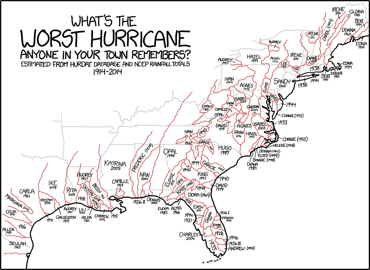
Which hurricanes are most remembered
28 October 2014
GIS Day at Rutgers
Join us in celebrating our fourth annual GIS Awareness Day 2014 at Rutgers University! We will have lightning talks, posters, networking opportunities...and refreshments! Learn how maps, GPS and satellite imagery are used for things like: cloud-based data collection for Trenton food system planning, tracking moose-car incidents in Alaska, putting a value on Jamaica Bay's ecosystem services, monarch butterfly conservation, ecological planning and more!
Speakers will represent a variety of regional organizations including: NJ DEP, USGS, Dept of Community Affairs, Rutgers University and private companies focusing on geospatial analysis. Nov 19th, 5-7 pm Rutgers University, IMCS building lobby (71 Dudley Road, New Brunswick, NJ) Our Facebook site: https://www.facebook.com/events/1489273881353563/ Everyone welcome to attend! Organized by RU Intermediate Environmental Geomatics students.
Speakers will represent a variety of regional organizations including: NJ DEP, USGS, Dept of Community Affairs, Rutgers University and private companies focusing on geospatial analysis. Nov 19th, 5-7 pm Rutgers University, IMCS building lobby (71 Dudley Road, New Brunswick, NJ) Our Facebook site: https://www.facebook.com/events/1489273881353563/ Everyone welcome to attend! Organized by RU Intermediate Environmental Geomatics students.
"If only every day could be GIS Day"

27 October 2014
Rutgers in the global news
Researchers at Rutgers are making waves with their findings that the temperature of the oceans is a more significant contributor to climate change than previously understood.
20 October 2014
Spatial dimensions of ebola
As the conversation about Ebola continues to mature at a relatively slow rate I found myself looking for some maps that would help me understand the problem a little better and found these from the UN's WHO.


But the CDC had a fairly different looking map that showed all of the African outbreaks since 1976:

National Geographic has time-lapse maps that document the speed at which the epidemic has spread.
This is clearly a spatial epidemic, but one that has more than one mappable dimension.
But the CDC had a fairly different looking map that showed all of the African outbreaks since 1976:
National Geographic has time-lapse maps that document the speed at which the epidemic has spread.
This is clearly a spatial epidemic, but one that has more than one mappable dimension.
17 October 2014
2014 Steve Strom Memorial Lecture
2014 Steve Strom Memorial Lecture
Susan K. Weiler, RLA, FASLA
OLIN

Since joining OLIN nearly 30 years ago, Susan Weiler has risen to prominence in the field of landscape architecture as a designer, speaker and writer. Her expertise in interfacing with complex engineering systems and construction technologies has applied to projects of myriad locales and typologies, including the US Embassy in Berlin, Germany; the Mission Bay Master Plan in San Francisco, California; LDS Conference Center in Salt Lake City, Utah; and the Anne d’Harnoncourt Sculpture Garden at the Philadelphia Museum of Art. She is currently leading OLIN’s design for Dilworth Plaza on the west side of Philadelphia’s historic City Hall. Susan holds a Bachelor of Science in Landscape Architecture from the University of Wisconsin and a Master of Landscape Architecture from the University of Pennsylvania, where she is now a longstanding faculty member.
She has lectured widely, including talks at the TEDx lecture series and panels at the American Society of Landscape Architects Annual Conference. Susan is co-author of the book Green Roof Systems: A Guide for the Planning, Design and Construction of Landscapes over Structure, which has become a primary resource on the topic of green roof design for landscape architects, architects and engineers.
Cook Campus Center, Multipurpose Room C Fall 2014 Common Lectures
Susan K. Weiler, RLA, FASLA
OLIN
Since joining OLIN nearly 30 years ago, Susan Weiler has risen to prominence in the field of landscape architecture as a designer, speaker and writer. Her expertise in interfacing with complex engineering systems and construction technologies has applied to projects of myriad locales and typologies, including the US Embassy in Berlin, Germany; the Mission Bay Master Plan in San Francisco, California; LDS Conference Center in Salt Lake City, Utah; and the Anne d’Harnoncourt Sculpture Garden at the Philadelphia Museum of Art. She is currently leading OLIN’s design for Dilworth Plaza on the west side of Philadelphia’s historic City Hall. Susan holds a Bachelor of Science in Landscape Architecture from the University of Wisconsin and a Master of Landscape Architecture from the University of Pennsylvania, where she is now a longstanding faculty member.
She has lectured widely, including talks at the TEDx lecture series and panels at the American Society of Landscape Architects Annual Conference. Susan is co-author of the book Green Roof Systems: A Guide for the Planning, Design and Construction of Landscapes over Structure, which has become a primary resource on the topic of green roof design for landscape architects, architects and engineers.
Cook Campus Center, Multipurpose Room C Fall 2014 Common Lectures
16 October 2014
Mike Catania
A couple weeks ago my studio got a fantastic tour of Duke Farms from Mike Catania. Now he is featured in a profile by NJ Spotlight. Coincidence?
Building project at Rutgers
Students learn about building and housing while raising money for charity.
13 October 2014
The DIRT on Phase 3 of the High Line
I really liked the different perspective in The DIRT's guest posting by photographer Allan Pollok-Morris about Phase 3 of the High Line.Can't wait to visit.
Short geodesign video
A highlight video from the 2014 Geodesign Summit in which I make a brief appearance.
10 October 2014
Open Houses and such
If you are interested in Geodesign you might want to check out the Philadelphia U. open house on November 1 where you can check out their program. Details here.
If you are interested in a Masters in Landscape Architecture you should try Rutgers' Open House on Saturday November 8th.
If you are interested in a Masters in Landscape Architecture you should try Rutgers' Open House on Saturday November 8th.
Subscribe to:
Posts (Atom)


