PLANNER-LAND USE/RESOURCEThe NJ Pinelands Commission, an independent state agency with regulatory jurisdiction over the million-acre Pinelands Area, seeks a full-time Resource Planner. Responsibilities include publication of the Commission’s periodic economic monitoring analyses, review of complex land use issues and municipal ordinances, coordination with other state agencies on infrastructure planning, and management of various water supply and water quality planning projects. GIS skills and experience with demographics, data manipulation and analysis required.Bachelor’s degree in land use planning or related field and one year land use planning or related experience required or equivalent combination of education and experience. Master’s degree in related field is a plus and may substitute for one year required experience.Only candidates selected for interview will be notified. For more information, see www.state.nj.us/pinelandsSend resume and cover letter by February 17, 2017 to Pinelands Commission, P.O. Box 359, New Lisbon, NJ 08064 or Fax: 609-894-7330 orE-mail: humanres@njpines.state.nj.us or complete an application at the Commission’s office, 15C Springfield Road, New Lisbon, NJ 08064.EOE.
31 January 2017
Environmental planning job
The NJ Pinelands is a Truly Special Place. How great would it be to help keep it that way?
30 January 2017
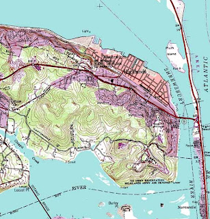
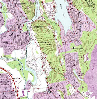
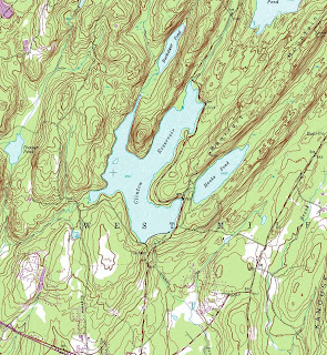
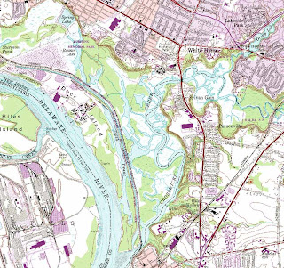
RotD: USGS Topo Maps
In class today we will be talking about ways to access the free USGS topographic quads for NJ online.
It is amazing to me to think how much the use of these has changed aver the years even though the maps themselves have changed so little. For those that are new to the maps, I am sharing some different scenes from around New Jersey that may be of interest. Just click on each and they'll expand.
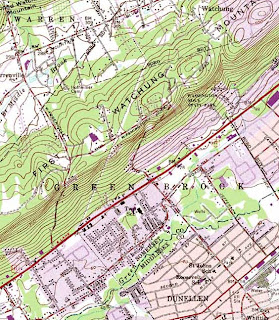
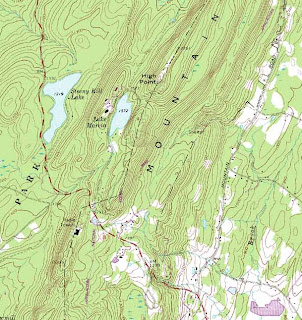
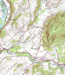
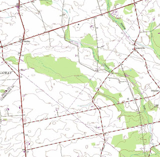
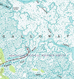
 A special thanks goes out to Mike Siegel and the Rutgers Cartography Lab. This is a great resource for students and for pros. A national resource is the Libre Map Project, but it is a bit harder for first time users.
It is amazing to me to think how much the use of these has changed aver the years even though the maps themselves have changed so little. For those that are new to the maps, I am sharing some different scenes from around New Jersey that may be of interest. Just click on each and they'll expand.


 A special thanks goes out to Mike Siegel and the Rutgers Cartography Lab. This is a great resource for students and for pros. A national resource is the Libre Map Project, but it is a bit harder for first time users.
29 January 2017
GIS freedom concerns
For those interested in geospatial information, it used to be a moment to celebrate when GIS got mentioned in proposed legislation. However, the GIS community is not celebrating this recently introduced bill.
This
bill was introduced in Congress (HR482 and S103) on January 17, 2017:
SEC. 3. PROHIBITION ON USE OF FEDERAL FUNDS. Notwithstanding any other provision of law, no Federal funds may be used to design, build, maintain, utilize, or provide access to a Federal database of geospatial information on community racial disparities or disparities in access to affordable housing.
26 January 2017
Ahwahnee Principles
On Monday I told some students about The Ahwahnee Principles for Resource-Efficient Communities. Will they get renamed as the Majestic Principles sometime in the future? Probably not.
24 January 2017
A moderate storm?
The Nor'Easter this week was pretty nasty but, as far as I can tell, not a hurricane and not a big killer. Because of that it is worth keeping an eye on the impact as a baseline for other events.
We'll talk about it in class on Thursday.
UPDATE:
- Video/photos of the tiki bar underwater got retweeted a lot.
- The beach erosion is pretty stunning if you haven't seen it before.
- The water in the streets of places like Ocean City seems like more than just a minor problem.
- The thousands of people without power hope that the power returns before their 5 gallons of ice cream melts.
- A viral video of some very wet streets in LBI near Ship Bottom
We'll talk about it in class on Thursday.
UPDATE:
— David Lospinoso (@david_lospinoso) January 25, 2017
19 January 2017
Poe's 208th
Today is Edgar Allen Poe's 208th birthday. There are plenty of places up and down the East Coast to celebrate, including Richmond, Baltimore and Philadelphia. But did you realize that there are 9 different Poe places in NYC?
If you can't get out, read some Poe!
If you can't get out, read some Poe!
Starting the spring with a planning post on housing
StrongTowns.org has a post that really works for the start of a new semester of planning.
Written by Nolan Gray, the post explains how Lexington (the best little city in America) could address its affordable housing shortage without compromising the city's famous urban growth boundary. So for a first day lesson, it already integrates the UGB and an important social and economic issue.
The article goes on to talk about mixed use, setbacks, parking, and little zoning tweaks that could make a big difference. For a first day conversation, it is a useful piece because it shows how planning often uses indirect levers to manipulate a problem. It also serves as a reminder that there is a lot to learn from informal sources, like non-profit blogs. Plus, Lexington is a great city that you should read about more often.
18 January 2017
Health Story Maps
As we kick off a new semester of the Honors Seminar linking mapping, design and health, it would be useful to think about some very different ways that maps can speak to health issues.
South Carolina has a very data-driven story map that allows side-by-side comparisons of health-related issues across the state. With maps like these, the biggest challenge may be the density of information that they contain.
A remarkably different example is a story-driven story map by a group called One Million Community Health Workers Campaign. Each story it tells is mapped, but the locations and the map are more about background and context than they are data.
The point is, not only are there many different types of health issues that can be mapped (obesity, infectious diseases, cancer clusters) but there are many different ways to map them. As we move ahead with our exploration of mapping technologies,
The point is, not only are there many different types of health issues that can be mapped (obesity, infectious diseases, cancer clusters) but there are many different ways to map them. As we move ahead with our exploration of mapping technologies,
16 January 2017
MLK Memorial
Today is a great day to reflect on the complicated histories of the MLK Memorial in Washington DC. It will get used heavily today, and may become a more popular site over the coming months.


07 January 2017
Appy New Year
A great way to start the year would be cleaning all of the old junk off of your smartphone. But then you'll need to reload it with new apps.
What apps should you get? Start with the PlaNetizen list of Best Planning Apps from 2017.
04 January 2017
5 Trends
According to Jack Dangermond, here are the 5 biggest trends impacting GIS. I probably don't give the location services enough attention. Maybe that should be my resolution for 2017.
Subscribe to:
Posts (Atom)


