One of our former students, Brian Curry, helped a team of researchers track down a new species of frog in out area. And now they have a paper out.
30 October 2014
29 October 2014
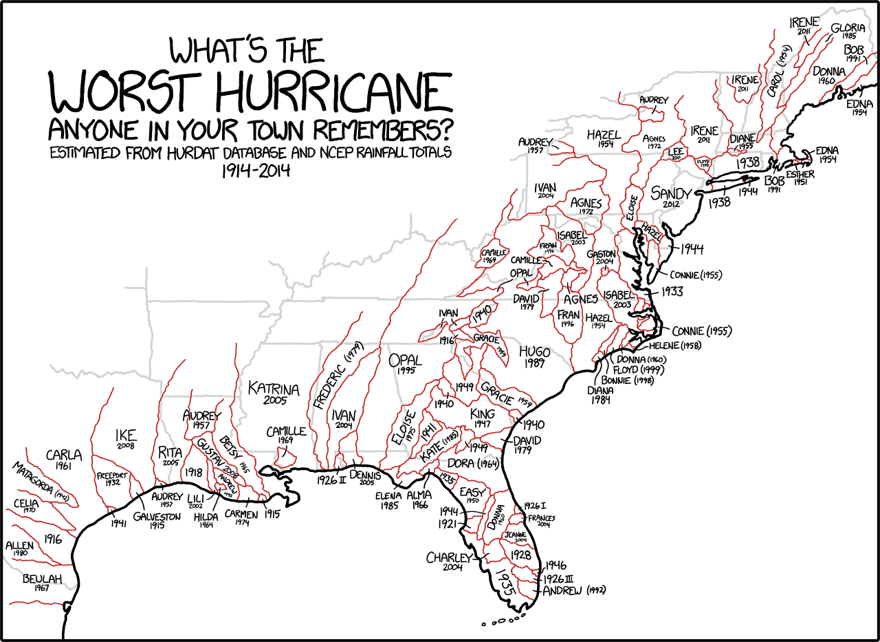
Which hurricanes are most remembered
28 October 2014
GIS Day at Rutgers
Join us in celebrating our fourth annual GIS Awareness Day 2014 at Rutgers University! We will have lightning talks, posters, networking opportunities...and refreshments! Learn how maps, GPS and satellite imagery are used for things like: cloud-based data collection for Trenton food system planning, tracking moose-car incidents in Alaska, putting a value on Jamaica Bay's ecosystem services, monarch butterfly conservation, ecological planning and more!
Speakers will represent a variety of regional organizations including: NJ DEP, USGS, Dept of Community Affairs, Rutgers University and private companies focusing on geospatial analysis. Nov 19th, 5-7 pm Rutgers University, IMCS building lobby (71 Dudley Road, New Brunswick, NJ) Our Facebook site: https://www.facebook.com/events/1489273881353563/ Everyone welcome to attend! Organized by RU Intermediate Environmental Geomatics students.
Speakers will represent a variety of regional organizations including: NJ DEP, USGS, Dept of Community Affairs, Rutgers University and private companies focusing on geospatial analysis. Nov 19th, 5-7 pm Rutgers University, IMCS building lobby (71 Dudley Road, New Brunswick, NJ) Our Facebook site: https://www.facebook.com/events/1489273881353563/ Everyone welcome to attend! Organized by RU Intermediate Environmental Geomatics students.
"If only every day could be GIS Day"

27 October 2014
Rutgers in the global news
Researchers at Rutgers are making waves with their findings that the temperature of the oceans is a more significant contributor to climate change than previously understood.
20 October 2014
Spatial dimensions of ebola
As the conversation about Ebola continues to mature at a relatively slow rate I found myself looking for some maps that would help me understand the problem a little better and found these from the UN's WHO.


But the CDC had a fairly different looking map that showed all of the African outbreaks since 1976:

National Geographic has time-lapse maps that document the speed at which the epidemic has spread.
This is clearly a spatial epidemic, but one that has more than one mappable dimension.
But the CDC had a fairly different looking map that showed all of the African outbreaks since 1976:
National Geographic has time-lapse maps that document the speed at which the epidemic has spread.
This is clearly a spatial epidemic, but one that has more than one mappable dimension.
17 October 2014
2014 Steve Strom Memorial Lecture
2014 Steve Strom Memorial Lecture
Susan K. Weiler, RLA, FASLA
OLIN

Since joining OLIN nearly 30 years ago, Susan Weiler has risen to prominence in the field of landscape architecture as a designer, speaker and writer. Her expertise in interfacing with complex engineering systems and construction technologies has applied to projects of myriad locales and typologies, including the US Embassy in Berlin, Germany; the Mission Bay Master Plan in San Francisco, California; LDS Conference Center in Salt Lake City, Utah; and the Anne d’Harnoncourt Sculpture Garden at the Philadelphia Museum of Art. She is currently leading OLIN’s design for Dilworth Plaza on the west side of Philadelphia’s historic City Hall. Susan holds a Bachelor of Science in Landscape Architecture from the University of Wisconsin and a Master of Landscape Architecture from the University of Pennsylvania, where she is now a longstanding faculty member.
She has lectured widely, including talks at the TEDx lecture series and panels at the American Society of Landscape Architects Annual Conference. Susan is co-author of the book Green Roof Systems: A Guide for the Planning, Design and Construction of Landscapes over Structure, which has become a primary resource on the topic of green roof design for landscape architects, architects and engineers.
Cook Campus Center, Multipurpose Room C Fall 2014 Common Lectures
Susan K. Weiler, RLA, FASLA
OLIN
Since joining OLIN nearly 30 years ago, Susan Weiler has risen to prominence in the field of landscape architecture as a designer, speaker and writer. Her expertise in interfacing with complex engineering systems and construction technologies has applied to projects of myriad locales and typologies, including the US Embassy in Berlin, Germany; the Mission Bay Master Plan in San Francisco, California; LDS Conference Center in Salt Lake City, Utah; and the Anne d’Harnoncourt Sculpture Garden at the Philadelphia Museum of Art. She is currently leading OLIN’s design for Dilworth Plaza on the west side of Philadelphia’s historic City Hall. Susan holds a Bachelor of Science in Landscape Architecture from the University of Wisconsin and a Master of Landscape Architecture from the University of Pennsylvania, where she is now a longstanding faculty member.
She has lectured widely, including talks at the TEDx lecture series and panels at the American Society of Landscape Architects Annual Conference. Susan is co-author of the book Green Roof Systems: A Guide for the Planning, Design and Construction of Landscapes over Structure, which has become a primary resource on the topic of green roof design for landscape architects, architects and engineers.
Cook Campus Center, Multipurpose Room C Fall 2014 Common Lectures
16 October 2014
Mike Catania
A couple weeks ago my studio got a fantastic tour of Duke Farms from Mike Catania. Now he is featured in a profile by NJ Spotlight. Coincidence?
Building project at Rutgers
Students learn about building and housing while raising money for charity.
13 October 2014
The DIRT on Phase 3 of the High Line
I really liked the different perspective in The DIRT's guest posting by photographer Allan Pollok-Morris about Phase 3 of the High Line.Can't wait to visit.
Short geodesign video
A highlight video from the 2014 Geodesign Summit in which I make a brief appearance.
10 October 2014
Open Houses and such
If you are interested in Geodesign you might want to check out the Philadelphia U. open house on November 1 where you can check out their program. Details here.
If you are interested in a Masters in Landscape Architecture you should try Rutgers' Open House on Saturday November 8th.
If you are interested in a Masters in Landscape Architecture you should try Rutgers' Open House on Saturday November 8th.
09 October 2014
Sad discovery in remote sensing
The BBC reports on how remote sensing is being used to look at the loss of Syrian heritage sites. They include before and after images of UNESCO World Heritage sites that are devastated by the war. Not a fun story, but a revealing look at distant events.
08 October 2014
Geodesign videos
One of the benefits of having Esri sponsor the Geodesign Summits is that there is a world-class video recording system built into the meeting room. The results is that I can easily share a few of my favorite talks.
There is a large library of videos on geodesign at Esri but also a decent number on YouTube.
Watch Arizona's Ryan Perkl show how geodesign can transform ecological design of wildlife corridors:
Or, watch the director of SOM's Black Box demonstrate the potential for parametric design of entire sections of a city.
If you dig around you can find quite a few of Carl Steinitz's geodesign presentations
And although they are a little long, the Bran Ferren videos are always a hit:
Talking about megacities
As an aside I will be mentioning some instant city and megacity issues to the students in our intro studio. You (and they) may find it interesting to read about some of the vacant instant cities that have been built but left unfilled. A few years ago National Geographic took a look at the instant cities phenomenon.
I have never visited one of the modern instant cities but I certainly have been to a megacity: Seoul. See below.


I have never visited one of the modern instant cities but I certainly have been to a megacity: Seoul. See below.
06 October 2014
Remapping the states on Slate
All week, Slate will be looking at different ways that the United States could be recast with new state lines, using digital mapping tools to help make their case. Today they started with a series of maps exploring equal distribution by showing 2 or 5 or 50 states all with equal population.
04 October 2014
Contested Territory
The NY Times' College Football Fan Map shows that Rutgers still has some work left if they want to claim to own New Jersey. I loved seeing Wisconsin in all solid red - I didn't see another state that was as solid. Can you find the Indiana fans in Indiana?
03 October 2014
Back to the city
A new report says that New Jerseyans are reversing the trend toward suburbanization and moving into walkable, livable cities.
02 October 2014
Subscribe to:
Posts (Atom)


