Trees are stressed and wilting from water loss in high heat. Leaves and limbs of redwoods, oaks, magnolias and other species are dropping, arborists say. Urban trees are joining the 12.5 million wild trees that died last year, according to the U.S. Forest Service.
29 February 2016
Drought policies impacting trees
The Washington Post says that California's trees are starting to feel the impacts of the State's water policies:
27 February 2016
Historic Maps
Take a break this weekend and check out these historic NJ maps. And definitely dig into the Historic New Brunswick Maps.
You can see old surveys...

The site includes Aero-views of some New Jersey cities.

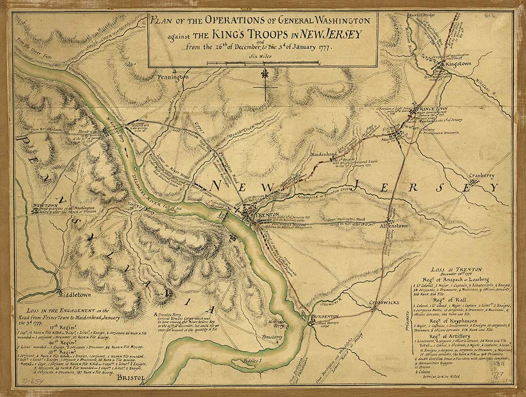
Some are about historic events like this Revolutionary War Map
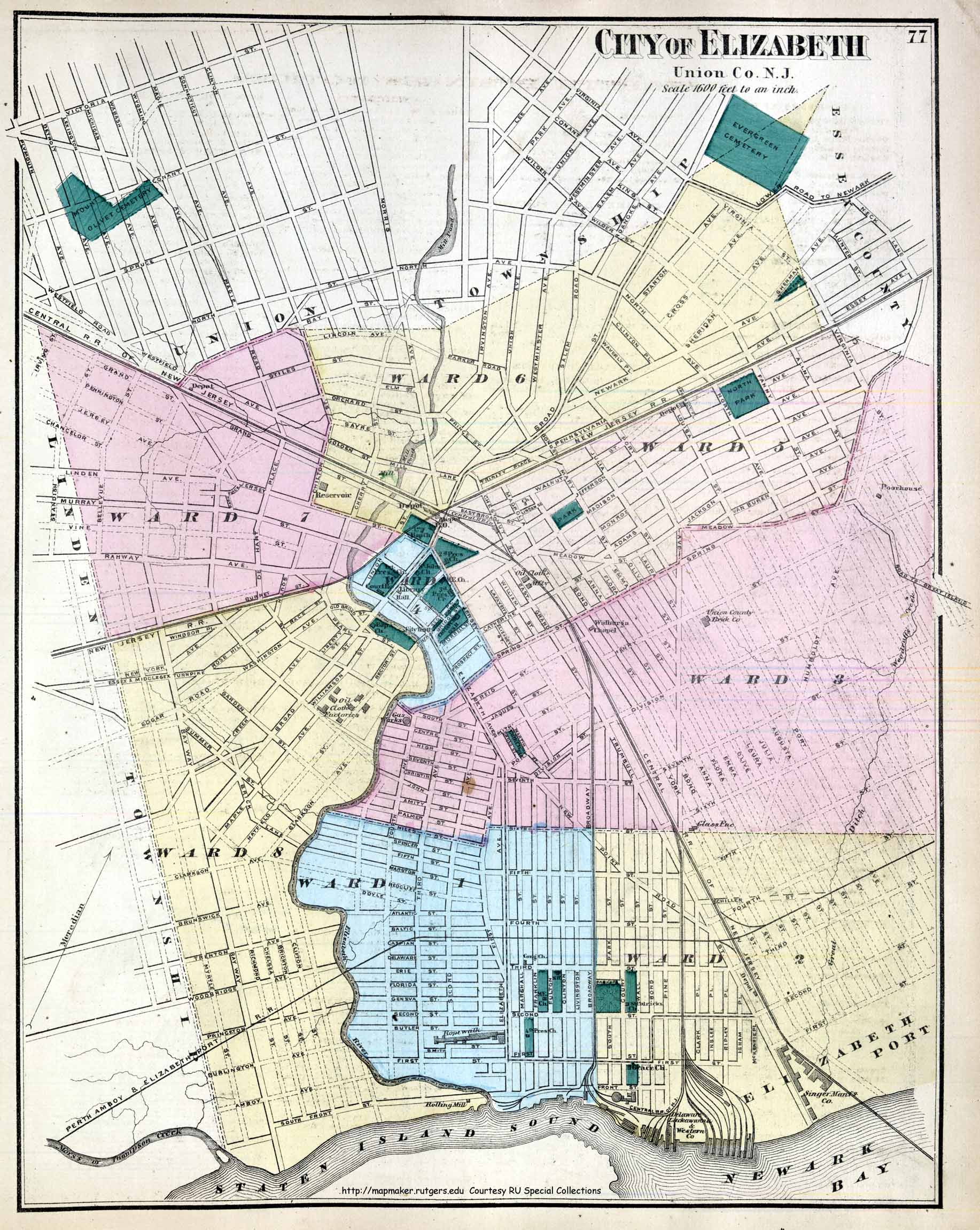
Some are official government maps of cities or counties.
 .
.
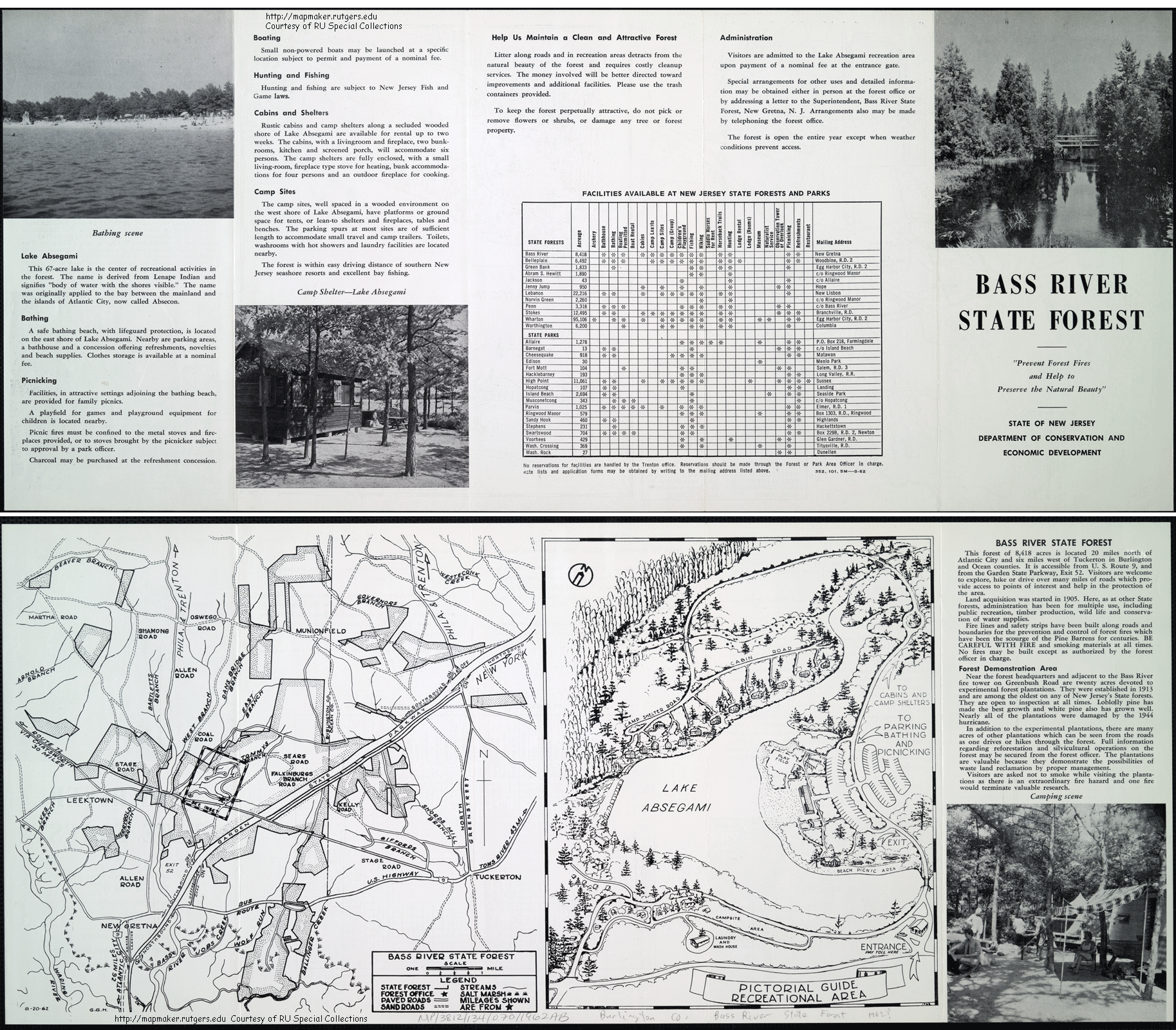
And some are just retro, like this 1962 map of Bass River State Park.
Just don't let the maps keep you from studying. Mid-terms are almost here.
You can see old surveys...
The site includes Aero-views of some New Jersey cities.
Some are about historic events like this Revolutionary War Map
Some are official government maps of cities or counties.
And some are just retro, like this 1962 map of Bass River State Park.
Just don't let the maps keep you from studying. Mid-terms are almost here.
26 February 2016
Population pyramids
Although I think that population pyramids are most interesting when made for smaller communities, the website, World Population Pyramids, lets you see them for most countries around the world, from 1950-2030. I found the graphs for Vietnam, which has undergone dramatic change during that period, to be fascinating. While many are so symetrical as to make you question whether they measure male and female distinctly, Qatar had fairly lopsided results.
I wish we had this for US counties.
I wish we had this for US counties.
25 February 2016
Sad loss
Yesterday New Jersey lost a colonial-era house due to a fire. It isn't just a loss of a fire. As a farmhouse, we also lose the ensemble that forms an historic farm. It is a damaged cultural landscape. Sad.
24 February 2016
Pizza and Tom's River
Thursday evening at 7, there is a talk by Dan Fagin, called Connecting the Dots in Toms River and Beyond, to be followed by a response from Kate John-Alder, SEBS Dept of Landscape Architecture. Fagin is a Pulitzer Prize-winning journalist and on the faculty at NYU. His book, Toms River: A Story of Science and Salvation, is about the dumping of industrial pollutants by chemical companies and the investigations of the cancer cluster that arose in Toms River. Institute for Food Nutrition & Health Rm 101.
Students are invited to have pizza with Dan Fagin at 5:30pm, before his talk. This is a great opportunity to have an informal Q & A with an investigative journalist covering important issues of science & society.
5:30 6:30 pm Dan Fagin, Pulitzer Prize winning author in non-fiction, pizza dinner with students and post-docs at IFNH.
Register at http://events.constantcontact.com/register/event?llr=ikvdmrfab&oeidk=a07ec97fnxk1e84b425
23 February 2016
Tree vs. Memorial
In Fundamentals we are talking about social and cultural landscape values. How do we decide when saving an old site is more important than progress? In Richmond, Virginia, a decision is being created pitting a memorial for Maggie Walker, the first African American woman to charter a bank in the United States, and an old oak tree.
The debate over the proposed memorial does not seem to ask whether the memorial is important. It simply focuses on questions about why the memorial and the tree cannot coexist. It is a large Southern live oak (one article described it as "towering") and the neighbors see it as a cultural treasure. It will be interesting to see whether the community gets drawn into a greater conflict.
The debate over the proposed memorial does not seem to ask whether the memorial is important. It simply focuses on questions about why the memorial and the tree cannot coexist. It is a large Southern live oak (one article described it as "towering") and the neighbors see it as a cultural treasure. It will be interesting to see whether the community gets drawn into a greater conflict.
19 February 2016
18 February 2016
Nordic Center Planica
If you are sick of the cold and snow, you might not want to look at these photos of a remarkably elegant ski jump facility in Slovenia. But if you find large, designed landscapes that change with the season to be interesting, the award-winning design from Studio AKKA is worth a peek. Their own modest description summarizes it this way, "The Nordic Centre at Planica is an intervention into the magnificent
Alpine frame and it’s symbolic charge, which renders all excessive
design absurd."
17 February 2016
Access to care
This story from Baltimore highlights how access to healthcare remains a key issue in understanding the health landscape.
The doctor told Sharlene Adams to get a blood pressure cuff, so Adams set out to buy one.
For Adams, who lives in West Baltimore, that meant four bus rides, a stop for a doctor’s signature, two visits to a downtown pharmacy for other medical supplies, a detour to borrow money for a copay, a delay when a bus broke down, and, at last, a purchase at a pharmacy on the east side of town.
The one-way, 7-mile trip took 5 1/2 hours. Then she had to get back home.
16 February 2016
Different ways to map online
In class we have recently talked about both:
a) ArcGIS.com and
b) NJ Geoweb.
We also mentioned that ArcGIS.com supports Story Maps, so here are a few favorites:
Top National Parks
Unemployment and Population Change
Ebola Outbreaks
GeoHealth Workshop at Rutgers
And I love it when it lets me burrow into a topic with multiple maps:
Natchez Trace Parkway Archaeology
Natchez Trace Scenic Stops
Lewis and Clark Animals
Lewis and Clark Plants
(The connection? Meriwether Lewis died on the Natchez Trace)
15 February 2016
Big storms and watersheds
Big storms don't just cause flash flooding. A new study from the Yale School of Forestry and Environmental Studies finds that the biochemistry of watersheds can be dramatically impacted. Building on what the authors call the "pulse-shunt concept," they show that these storms push large quantities of organic material past the watershed's headwaters and further downstream. This results in changes in levels like phytoplankton. Ultimately, they suggest, that it could also change dissolved oxygen levels and water clarity.
14 February 2016
12 February 2016


11 February 2016
Almost like free GIS
The online mapping applications at NJ DEP are incredibly helpful, especially for people working without GIS software. These days the main app is NJ Geoweb which loads in a web browser.
NJ Geoweb not only allows you to map and overlay dozens of layers, but it also supports some basic analyses. The municipalities layer lets you look at the utterly ridiculous shape of South Hackensack. The proximity tools allow users to select all of the parcels (or schools, or dry cleaners) within 1000 yards (or 50 feet) of selected streams (or municipalities or day care centers).
I am surprised that I haven't already heard more stories of citizens showing up at planning board meetings with custom maps and analysis from NJ Geoweb. Maybe this will be the year.
Wildlife
Many would think that New Brunswick and New Jersey are a terrible place for wildlife. Admittedly, we could do a lot to make it better. But there is a lot already here.
Just a short walk from our campus is the Raritan River which helps provide critical habitat for an amazingly diverse community of plants and animals. Bald eagles and peregrine falcons regular work the river near us and Joe Mish has written about some of the not-so-hidden ecology on the banks. Don't just read it. Head and see some great places in our backyard.
Just a short walk from our campus is the Raritan River which helps provide critical habitat for an amazingly diverse community of plants and animals. Bald eagles and peregrine falcons regular work the river near us and Joe Mish has written about some of the not-so-hidden ecology on the banks. Don't just read it. Head and see some great places in our backyard.
09 February 2016
Lathrop Homes
Here is a story to watch for a while. It seems unlikely to get resolved without a few rounds of news coverage.
In Chicago, an old housing project is getting update. In an effort to turn the historic project into a riverfront destination, some buildings will be torn down and others will be renovated. The proposal is for a mixed income development that will feature kayak launches and lush parks.
The Chicago Tribune describes the proposed changes this way: "The exterior of the historic buildings would be restored to their Depression-era luster, while the buildings will be gutted and updated with modern amenities. New buildings would be designed to fit with the original architecture." It will include But the project is controversial. Perhaps because project reduces the number of affordable units from 925 to 525. But the Tribune says that there are currently only 140 low-income families living there.
The slideshow accompanying the Tribune story gives a sense for some community protests and concerns. Curbed reports that the landscape architecture is being designed by MVVA.
The projects were named after Julia Lathrop who led the United States Children's Bureau from 1912 to 1922.
08 February 2016
Hoboken's plan
The NY Times takes a longer look at Hoboken's engineered approach to resiliency. At its heart, the plan uses structures that work like floodwalls. But in Hoboken, that has turned out to be so controversial that Mayor Dawn Zimmer has developed an alternative vocabulary. The Times says that, "Instead, she is careful to use less provocative terms, such as a
“flood-protection measure,” and emphasizes that a wall could double as
an “amenity,” such as a bench or planter, that would fit into the urban
landscape."
In Fundamentals, we just finished talking about some participatory planning methods. The article highlights the difficulty that those present. But it might also demonstrate the value of choosing the right ones.
Meanwhile, this morning's high tide has Jersey Shore towns under water. Keep an eye on the photos getting reposted by the Twitter account @JSHurricaneNews.
05 February 2016
Staten Island resiliency changes
NY1 reports that since Superstorm Sandy, New York CIty's Build it Back program has elevated 25 homes in Staten Island above the floodplain. But these elevated homes change the feeling of the neighborhood fairly dramatically.
NY1 writes that "the problem is, while some are raising their homes so they can get cheaper flood insurance, others are choosing not to." But there is also the simpler problem that it changes the street into an unintended canyon that the designs don't address. We are going to see more of this near our shores, especially in urban neighborhoods, with designers starting to propose some interest solutions.
The Rutgers LA Housing Studio taught by Kate Higgins took a look at how resiliency-driven design decisions could change a neighborhood at the shore. Check out the video.
04 February 2016
New map design book
Map design fans will be excited. Cynthia Brewer has a new book out promoting ideas behind designing better maps. And, because it is 2016, Esri Press has a 2 minute video describing the book.
03 February 2016
Health mapping examples
In class today we talked about Public Participatory GIS and VGI. Some of the applications are important socially relevant crowdsourcing efforts like Tomnod but others are popular, like
the bathroom mapping story in the New Yorker.
We also looked at public sources of mappable information like NYC Open Data or the Health Data at Data.Gov.
While there were lots of examples of community projects, there were also some health research projects that were mentioned including series of maps investigating health at IMMemphis. This included mapping of Ebola tweets.
One of the issues is really scale. When you hear about someone mapping cases of Zika, you probably think of something different than this map that TIME has posted.
02 February 2016
Parks lecture
Nette Compton
Senior Director of Park Central and City Park Development
The Trust for Public Land
Common Ground: Parks as a driver for public process and community empowerment
Parks play a critical role in the civic life of cities - places to reflect, play, relax, and interact with the community. A successful park is not only based on its size, location, and physical features; the life of a park is in its ability to be used flexibly by a wide range of people, conveying a sense of ownership and welcoming that endear a park it its neighbors. Landscape architects must consider how best to create these vibrant public spaces not only through the built form of a park, but in the process itself. Community engagement in the process of building a park is not just an opportunity to receive feedback on program and layout; it is an opportunity to instill interest and momentum around the value of the park, fostering a network of stewards and advocates long after the ribbon is cut. Presentation to include a collection of case studies demonstrating this process, and a discussion of how landscape architects can play a central role in leading this process.
February 3, 2016 4:00 – 5:30 p.m.
Cook/Douglass Lecture Hall, Room 110
Cook Campus
01 February 2016
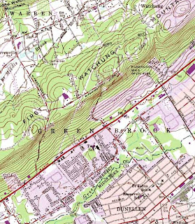
USGS Topo maps
In class today we will be talking about ways to access the free USGS topographic quads for NJ online. It is amazing to me to think how much the use of these has changed aver the years even though the maps themselves have changed so little. For those that are new to the maps, I am sharing some different scenes from around New Jersey that may be of interest. Just click on each and they'll expand.
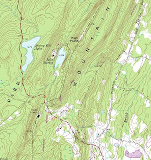
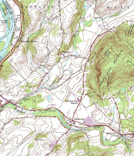
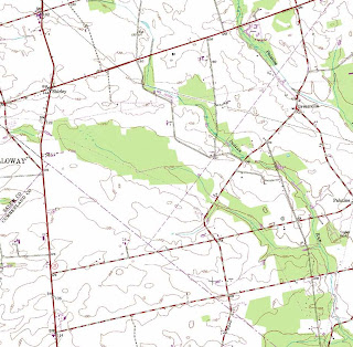
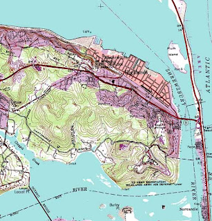
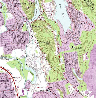
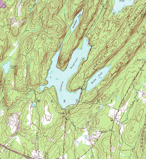
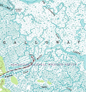
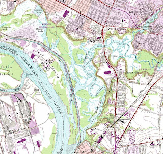 A special thanks goes out to Mike Siegel and the Rutgers Cartography Lab. This is a great resource for students and for pros. A national resource is the Libre Map Project, but it is a bit harder for first time users.


 A special thanks goes out to Mike Siegel and the Rutgers Cartography Lab. This is a great resource for students and for pros. A national resource is the Libre Map Project, but it is a bit harder for first time users.
The changing face of libraries
The campus library is undergoing a dramatic change as physical books are taking a back seat to digital indices and search resources. So what happens at the campus library? It the new design for Temple's main library, Snøhetta wants to make it "a new social and academic heart for the campus." It will be interesting to watch as they transform the neighborhood (below) with the reality of this new vision. But it is interesting to see that their renderings include a winter scene, which represents a substantial portion of the academic year in North Philadelphia.
Subscribe to:
Posts (Atom)


