
29 August 2014
Irresponsibility
November 2014 vote on open space: "I'll be voting no," Christie said during a news conference today in Sea
Bright. "It's irresponsible to earmark (money) this way."
28 August 2014
Killing Time?
When people saw that this one plane was "pacing back and forth" it seemed suspicious. After all, this plane was low and slow. But the website Metabunk.org, which "is dedicated to the art and pastime of honest, polite, scientific debunking" took a closer look. Turns out it wasn't a North Korean bomber or aliens, but LiDAR.
Hence the new motto I propose: "LiDAR - Not as scary as aliens."
Hence the new motto I propose: "LiDAR - Not as scary as aliens."
27 August 2014
Organized information
Through much of the literature of GIScience there is a theme of information organization. Information about metadata seems pretty meta, sometimes. But this List of lists of lists from Wikipedia top it all.
26 August 2014
Using maps for tough issues
FiveThirtyEight blog found itself turning to maps to explain some elements of the Michael Brown shooting and public response. With tough issues, like race and income, the maps tell a more complete and nuanced story than the statistics that 538 is so famous for. I think that in situations like these, they feel more true than simple numbers. But, just as importantly, as many readers are still trying to understand the basic landscape of the area, they provide a richer context.
25 August 2014
Lower Raritan partners and possible friends
The Lower Raritan Watershed is a large area and there are a lot of different groups that are either interested in it, or useful to those interested in the watershed. For our students, this list gives you some to explore, but is not close to being complete. It avoids companies and government groups except for environmental commissions.
Edison Wetlands Association
Riverkeeper
Lawrence Brook Watershed Partnership
The Watershed Institute
Central Jersey Bicycle Club
Raritan River Project at No Water No Life
American Littoral Society
Edison Greenways Group
East Coast Greenway
Highland Park Environmental Commission
Cranbury Environmental Commission
NJ Audubon
Endangered New Jersey
The NYNJCTBotany site has plant inventories for many sites within the watershed including (but not limited to) the Monmouth Battlefield State Park (in Monmouth County), Washington Valley Park (is Somerset County), Triple C Ranch (in Middlesex County), and the Watchung Reservation (in Union County).
23 August 2014
Art as landscape
Olafur Eliasson has outdone himself this time with a stream installation inside an art museum in Denmark.

Since you might not make it to Denmark this fall, you might have to settle for seeing art in other places.

Since you might not make it to Denmark this fall, you might have to settle for seeing art in other places.
20 August 2014
Paper for CyberGIS '14
In my talk at CyberGIS '14, I referenced Will Craig's paper:
Craig, W. 1992. "Why we couldn't get the data we wanted," Journal of the Urban and Regional Information Systems Association (URISA), Vol. 4 No. 2. 1992.It is a timeless paper. Although the technology has changed a bit, the basic ideas behind institutional and social barriers to data access haven't.
More urban innovation
Next Cities announces a new infusion of funding for urban innovation:
Bloomberg Philanthropies announced Wednesday a three-year commitment that will send eligible cities up to $1 million annually to support the creation of “innovation delivery teams” that will use data-driven, results-oriented approaches to solve vexing urban problems.
19 August 2014
Big Data is hard work
So says the NY Times today.
“It’s an absolute myth that you can send an algorithm over raw data and have insights pop up,” said Jeffrey Heer, a professor of computer science at the University of Washington and a co-founder of Trifacta, a start-up based in San Francisco.Yup.
Phil Lewis' maps go online
Fans of retired landscape architecture professor Phil Lewis will want to check out the digital maps that were created of his 1964 Landscape Resource Inventory. Those not knowing who he is should go back and read his book.
CyberGIS '14
This week a group of researchers has gathered at CyberGIS '14 to look at how better, more interconnected computers are transforming GIS. While supercomputers and big data seem like something that only interests a handful of researchers, but what can be done today on Blue Waters or Keeneland will be done on a desktop or phone sometime in the not-so-distant future.
If you can't drop by, you can follow along. Several users, particularly Esri's Dawn Wright, are tweeting throughout the meeting at #CyberGIS14. And there may be some live streaming video at some point.
If you can't drop by, you can follow along. Several users, particularly Esri's Dawn Wright, are tweeting throughout the meeting at #CyberGIS14. And there may be some live streaming video at some point.
#CyberGIS14 streaming live at http://t.co/OOLGz1wtyj with passwd watch.uc14
— CyberGIS Center (@CyberGISCenter) August 19, 201418 August 2014
Rutgers Bamboo Garden
The Hidden NJ blog made a stop earlier this month at Rutgers Gardens and wrote up the Bamboo Garden. It is fun to see such a familiar place as seen through a fresh set of eyes. If you haven't been, this would be a great summer to do so.
15 August 2014
Crowdsourcing the British Isles
FiveThirtyEight takes a closer look at the website, Geograph, which it says "contains photos of 97 percent of the 244,034 one-kilometer squares of Great Britain and 41 percent of Ireland and Northern Ireland’s 87,933 grid squares." Crowdsourced photos to cover a place aren't new, but at this level the effort is amazing.
Friday Fotos: Four Freedoms Park
"In the future days, which we seek to make secure, we look forward to a world founded upon four essential human freedoms.
The first is freedom of speech and expression—everywhere in the world.
The second is freedom of every person to worship God in his own way—everywhere in the world.
The third is freedom from want—which, translated into world terms, means economic understandings which will secure to every nation a healthy peacetime life for its inhabitants—everywhere in the world.
The fourth is freedom from fear—which, translated into world terms, means a world-wide reduction of armaments to such a point and in such a thorough fashion that no nation will be in a position to commit an act of physical aggression against any neighbor—anywhere in the world.
That is no vision of a distant millennium. It is a definite basis for a kind of world attainable in our own time and generation. That kind of world is the very antithesis of the so-called new order of tyranny which the dictators seek to create with the crash of a bomb."
- Franklin D.
Roosevelt
I finally made it to the newest plaza by the late architect, Louis I. Kahn. Years after the death of the controversial architect, Four Freedoms Park finally opened on the southern tip of NYC's Roosevelt Island. A glimpse of the lengthy process is captured online by WIRED New York. Vanity Fair published a review that compared the space with other posthumous projects.
Not unlike other plazas Kahn designed, at its heart, Four Freedoms Park is about hardscape space and form. For most, the entry into the space will require climbing a 100 foot wide set of stairs. The climax is the arrival at a stone room that forces the visitor's eyes out onto the water, with high walls blocking the side views of Manhattan and Queens.


At the top of the staircase visitors are treated to a green space lined with double rows of lindens, converging on the final plaza.


Getting in and out of the site currently requires visitors to confront Roosevelt Island's rather creepy past.

Even though a firm was hired to touch up Kahn's original designs and make them ADA compliant, the climactic waterfront section was roped off, preventing the public from what seemed like the intended ultimate viewing experience of the park. When I asked the security guard, he said that since the section was only accessible by steps it was not ADA compliant and had to be closed to everyone. I'll trust that there is more to this story than his simple explanation, but can not find anything online that is helpful.


BTW, if you haven't seen the documentary, My Architect, made by Kahn's son, you should check it out.
14 August 2014
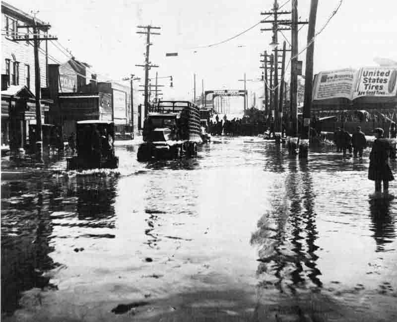
Lower Raritan River: Reslilent?
Here are a few of my Hurricane Irene photos from August '11 on the banks:


 The Star-Ledger ran a graphic several years ago that shows areas of New Jersey that would be most impacted by sea level rise. Sure, the beach communities are going to get wet. I hear that it floods in Monmouth beach everytime it gets cloudy. And Atlantic City will be "elevation challenged". But look how far inland the impacts are on the Raritan. And Middlesex County spent all that money on its new marina.


--------------------------------------------------------------------------
After Superstorm Sandy, I didn't get river photos, but found some from nearby in Highland Park. Downed trees and gas lines. Is the watershed ready for more?
------------------------------------------------------------------------------
And make sure you take the way back machine to 1999 and look at Dr. John Hasse's scrapbook photos of the flooding from hurricane Floyd.
-------------------------------------------------------------------------The Star-Ledger ran a graphic several years ago that shows areas of New Jersey that would be most impacted by sea level rise. Sure, the beach communities are going to get wet. I hear that it floods in Monmouth beach everytime it gets cloudy. And Atlantic City will be "elevation challenged". But look how far inland the impacts are on the Raritan. And Middlesex County spent all that money on its new marina.13 August 2014
Lower Rariran River: The river itself
This week I've been posting some resources about the Lower Raritan River as we get ready for a fall studio investigating the region. Today's resources are about the river itself.
With hurricane season upon us, watching the river go up and down becomes a popular pastime.
After the recent storms, watching the graphs of the river gauges rise can be exciting:
USGS Raritan River at Manville
USGS Raritan River Gage below the Calco Dam
Flows will change as they keep pulling out the dams along the river. Watch a couple of the dams go away.
Of course, to some, a big river is all about fishing. Here is a video of a catch on the Raritan up by Manville.
And another of a kid pulling in a striper
12 August 2014
Another planning meeting shut down by over-capacity crowds
New Brunswick's Planning Board meeting had to adjourn because the chambers lacked room for all of the members of the public that came to participate. Democracy would be awesome if we had room for it.
Lower Raritan Historical Maps
Returning to Mike Siegel's New Jersey Historical Maps, the 350 square miles of the Lower Raritan Watershed have produced some remarkable map products.
This aerial perspective map of New Brunswick from 1910 captures in great detail how the city looked when factories still lined the banks.
 More functional than historic, this 1968 Master Plan for Edison anticipates a largely industrial future rather than the town of over 100,000 that it has become.
 John Brush used historic records to create this 1850 map of Piscataway.


This aerial perspective map of New Brunswick from 1910 captures in great detail how the city looked when factories still lined the banks.
Ever hear of Herbert? It was to be a development near Spotswood, not far from what is now Route 18.
A recent map of what used to be one of the oldest settlements in New Jersey. Remnants were found as recently as 2008.
And we have the Battle of Monmouth, birthplace of the legend of Molly Pitcher.
Quote about thinking
“No brain at all, some of them [people], only grey fluff that's blown into their heads by mistake, and they don't Think.”
― A.A. Milne, The House at Pooh Corner
11 August 2014
Lower Raritan Historical Photos
In 1937 New Brunswick looked ready to take off!

Landing Lane Bridge looks different in this 1976 photo, but you can also see what is about to become the Route 18 bridge across the Raritan River.

It is a little tricky finding High Point Solutions Stadium in this old photo from 1952 (?) because the stadium wasn't called that back then (and it was much smaller).

In 1964 you could still see the industrial past of New Brunswick along the Raritan.

The 1920s photo of flooding on Albany Street seems eerily familiar.
Down in North Brunswick crowds turned out to watch them dig out what became Georges Road.

On the banks of the old Lawrence Brook, not far from the mighty Raritan River.

10 August 2014
Highlands Act turns 10
New Jersey's Highlands Act is 10 years old. The Star-Ledger published a guest column called, "Highlands Act still a good deal a decade later: Opinion." Some will argue that the Act has lost its momentum and isn't having a noticeable impact anymore. The column, by Julia Somers (executive director of the New Jersey Highlands Coalition) and Elliott Ruga (the coalition’s senior policy analyst), counters that the next few years are going to a key time for the Highlands Council. To be ready, they say, we need "to remind ourselves why the law was needed."
08 August 2014


Mark your calendars
For more than 20 years, CUPUM (Computers in Urban Planning and Urban Management) has been one of the premier international conferences for the exchange of ideas and applications of computing technologies to address a diverse range of social, managerial, and environmental problems impacting urban planning and development.
The 14th International Conference on Computers in Urban Planning and Urban Management (CUPUM) will be held at MIT in Cambridge, Massachusetts USA on July 7-10, 2015.
The 14th International Conference on Computers in Urban Planning and Urban Management (CUPUM) will be held at MIT in Cambridge, Massachusetts USA on July 7-10, 2015.
07 August 2014
When do people search on National Parks?
As I look forward to another semester of teaching the Byrne Seminar on National Parks, I thought this GoogleTrends graph was revealing. It isn't a surprise that Grand Canyon towers over the other two, but the seasonal nature of National Parks data might be a surprise to some.
06 August 2014
05 August 2014
Cultural history
Creative use of big data and technology is starting to create new ways to see patterns and trends. Northwestern reports on scholarly outputs there that are letting us watch the changing cultural heritage of the American landscape.
“We’re starting out to do something which is called cultural science where we’re in a very similar trajectory as systems biology for example,” said Schich, now an associate professor in arts and technology at the University of Texas at Dallas. “As data sets about birth and death locations grow, the approach will be able to reveal an even more complete picture of history. In the next five to 10 years, we’ll have considerably larger amounts of data and then we can do more and better, address more questions.”Their paper in Science says that they "have reconstructed aggregate intellectual mobility over two millennia through the birth and death locations of more than 150,000 notable individuals. The tools of network and complexity theory were then used to identify characteristic statistical patterns and determine the cultural and historical relevance of deviations." Mapped out, we can see what it means spatially.
04 August 2014
Is Big Data near the top of the S curve?
Is Big Data still a growing topic or is it about to top out?
Wish we could know.
New executive director at the US Botanic Garden
Rutgers graduate Ari Novy has been named the new executive director of the US Botanic
Garden. Many of our more recent alumni learned their plants from Dr.
Novy. But now visitor's to the Capitol can learn from his work too.
01 August 2014
They know you so well
Esri has opened the doors to make their Tapestry Segmentation more accessible with some interesting online maps and data presentations. The College Towns and Enterprising Individuals who read Places and Spaces may find their description of them eerily correct. The Diners and Miners seems less problematic than Shotguns and Pickups.

 With the tagline of, "We are a nation of ZIP Codes and neighborhoods," I don't think that Esri has made Tapestry Segmentation any less creepy than the Claritas Prizm groups.
Maybe they should just go with, "We know what you'll buy before you do." or, "You are from
But will planners use this? Will they trust the data and make decisions at this level? Or do they already have better micro-knowledge internalized?
Maybe they should just go with, "We know what you'll buy before you do." or, "You are from
But will planners use this? Will they trust the data and make decisions at this level? Or do they already have better micro-knowledge internalized?
Interchanges is back!
In response to the overwhelming popular demand, Interchanges will return for the month of August with 31 different vacation interchanges. Can you figure out the vacation destination at this exit? Keep checking Interchanges to get the answer.

Subscribe to:
Posts (Atom)


