30 September 2009

3 Landscapes: Eric Sanderson

Arches National Park
The Red Ribbon - Tanghe River Park
The High Line

For background, go here: http://tulloch.rutgers.edu/Candidates.html

LiveBlog: Eric Sanderson on Mannahatta

Eric Sanderson
Mannahatta: A Natural History of New York City
The Fall 2009 Environmental Planning Lecture

So right up front we have to acknowledge that today's talk brings with it some extra attention. The Mannahata Project has a highly visible website with data as well as plenty of attention from the NY Times and WNYC's Leonard Lopate Show. Rutgers alum Kate John-Alder recently wrote a review in the Architect's Newspaper. If you want depth, you should start with Kate's review. This is just a LiveBlog...

MuirWeb and Mannahatta - making the invisible, visible
Mannahatta, the isle of many hills

It all started with a map found
His work at the World Conservation Society (Bronx Zoo) led him to this map that went back before the usual early histories
. . . . Father Duffy

NYC was the first megacity - Now there are 18, soon there'll be 27

1782 or 1783


Fort Kniphausen - Fort Washington

What if we could take the streets off and go further back in time.
Sanderson's team made an historic DEM, added spotty data, and ran a human habitat model
. . the best places were around Collect Pond, near Chinatown and City Hall
. . . similarly they could look for Lenape field where they might have grown the three sisters - corn, beans, and squash
. . . they could model the 55 different ecosystem types that came up as most likely - he thinks of these as being the neighborhoods for plants and animals - more than Yellowstone has on a per acre basis
Sorry, no PowerPoint comas today. This was an ArcGIS dependent presentation.

Home Reconstructed
He enjoys looking for similar landscapes to the original places
  • Hempstead Plains Grassland
  • Coastal Appalachian Oak-Pine Forest
  • Rocky Headwater Stream
  • High and Low Salt Marsh
The Lenape were written about by Penn - today we think about 3-600 people lived on the island.

Animals were plentiful
  • Beavers were probably o all 66 miles of streams
  • Heath hens
  • Deer and maybe elk
  • Wolves
  • Black bear
WCS looked at habitat conditions based on four characteristics
  • Food
  • Water
  • Shelter
  • Reproductive resources
And they started recognizing the networks that were present in these habitat and species relationships - it led them to the MuirWeb
It features a density of relationships that make it robust, dynamic and resilience
The MuirWebs are named for John Muir (a real shaper) who said:
"When we try to pick out anything by itself, we find it hitched to everything else in the Universe."

With Markley Boyer he then illustrated the best estimation of how it looked.

The old and new are both pretty special. Can it last for another 400 years?


As his epilogue, he points out how humans need more than Food, Water, Shelter, Reproductive resources, we also need Meaning. But have we spent so much time worrying about Meaning that we have neglected the others?
What if we brought back the streetcars and added greenroofs? Can we think regionally again?
The #1 agricultural county in the US used to be Queens. Can it come back?

What would it look like then?


View Larger Map

McDonalds gaps


Although this has already been blogged at several of my favorite Internet haunts, it is worth relinking here too. The Weather Sealed blog has posted a map showing the farthest places from a McDonald's in the US. He includes a link to what he call the McFarthest spot, the least McDonaled place in America.

29 September 2009

Book Signing and Lecture


The Fall 2009 Environmental Planning Lecture

Mannahatta: Dr. Eric Sanderson
Wednesday, September 30 @ 4:00
Alampi Room, Institute of Marine & Coastal Sciences
(Book signing after lecture)

More art book than typical natural history book, Sanderson and Boyer recreate the ecology of Manhattan in Mannahatta as it was that 1609 September afternoon when Henry Hudson first saw it. The Mannahatta Project is a current exhibition at the Museum of the City of New York; the book is a New York Times Best Seller; it is on this month’s cover of National Geographic.

The Mannahatta Project began a decade ago, when landscape ecologist Dr. Eric Sanderson, a native Californian, moved to New York City to work for the world famous Wildlife Conservation Society at the Bronx Zoo. Dr. Sanderson realized that, to fully appreciate the concrete landscape of streets and buildings that was his new home, he would have to “go back in time” to recreate the its ecology from the “ground up.” As a landscape ecologist, Dr. Sanderson uses spatial analysis techniques to protect wildlife in modern landscapes. His revolutionary idea was to apply these techniques to recreate an extinct, historic landscape in detail, that is, to recreate, in digital form using mapping software, each and every hill, valley, stream, spring, beach, forest, cave, wetland, and pond that existed on Mannahatta.

"The larger idea here is that the best way for the city to plan ahead is to look back."

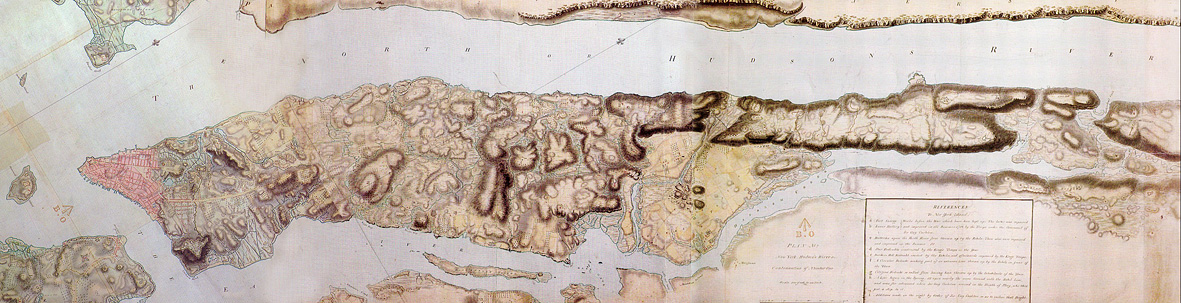
The goal of the Mannahatta Project has never been to return Manhattan to its primeval state,” Sanderson writes. “The goal of the project is to discover something new about a place we all know so well, whether we live in New York or see it on television, and, through that discovery, to alter our way of life. New York does not lack for dystopian visions of its future. . . . But what is the vision of the future that works? Might it lie in Mannahatta, the green heart of New York, and with a new start to history, a few hours before Hudson arrived that sunny afternoon 400 years ago?

28 September 2009

Ecology & Evolution Graduate Program Seminar
Dr. Michael Wimberly
Geographic Information Science Center of Excellence
South Dakota State University

The macroscope meets the microscope: climate, land cover, and the biogeography of infectious disease.

Thursday, October 1, 2009

4:00 p.m.
Alampi Room, Marine and Coastal Sciences

GeoEye imagery from Iran

Geospatial technologies have a multitude of applications. cNet reports on GeoEye's release of satellite images of Iran's newest controversial site.

24 September 2009

A greener Harvard Yard

The NY Times reports that Harvard Yard has turned to an organic alternative to synthetic fertilizer.

Archive magic

The Library of Congress' American Memory collection is a great online source of materials. To demonstrate, I have pulled a few examples from Boston. They illustrate how even some innocuous sites may have a special history.

Here is Harry Houdini preparing for his Harvard Bridge jump...


There are quite a few available aero-maps of Boston.


And the Revolutionary Era maps of the city are revealing.

And HABS/HAER has drawings and photos.
Explore and enjoy.

23 September 2009

Bits of Landscape: Links from ASU talk

As a departure point for asking how emerging online apps are changing (or aren't) the future of planning and design, we peeked at some of these widely available sites and applications:

Wikimapia
Common Census
NJ LA Sites

Wired gives you a guide to Second Life
Rutgers has a Second Life page
too.
For the less digitally inclined there is First Life


Some of these examples come from "Many, many maps: Empowerment and online participatory mapping" in the First Monday journal.

Faux-LiveBlog: Rutgers LA Studies in Italy

Italy Students: Ty, Sarah, Hany, Jenna, Zeina, Mike, Rebecca, Steve
Study Abroad: Italy

(Since I can't make this week's lecture, I'll just have to guess what is being said)


The students attest unanimously that this is the best experience of their lives. One received a scholarship from SEBS - more should apply next year. And Ari Novi's knowledge and experience on Italian gardens was an incredible asset for the entire class and made such a difference. And the gardens of Tuscany really may be the best in the world.

If you haven't studied abroad, you should. Your next chance is the Winter Session trip to the Yucatan Peninsula in Mexico.

Learn. Love. Live.

(Was I close?)

22 September 2009

GeoDesign Summit 2010

Can landscape architecture and environmental geomatics really coexist peacefully? For years, we have successfully combined them as separate tracks in the same option here at Rutgers. They seem closely linked, yet the lessons from Harvard Computer Graphics Lab seem lost when we look at the growing divide between contemporary work in LA and GIS.

ESRI has announced that it will be hosting the GeoDesign Summit in 2010 in Redlands. Two of the three "sponsors" are schools, neither of which has a landscape architecture or architecture program. Is that a good thing?

This doesn't come out of the blue. Last year UCSB hosted a workshop on the topic. Earlier this year Jack Dangermond published a large feature on design in ArcNews. (It included graphiced-up Steinitz's framework diagram) And the ESRI opening plenary this summer featured a 16 minute presentation on design by Dangermond (video).


The Dirt on ASLA

In case you didn't go to Chicago, The Dirt is recapping some of the more notable presentations at this year's ASLA. Presentations covered include a look at changing cities in a climate change world, the economics of the London Olympics, and the green streets program from Vancouver.

21 September 2009

Capitol lawn statue of George Washington as Zeus

While preparing for our upcoming fall field trip to Boston, I was reminded of this classic photograph from the Library of Congress showing a school group studying statue of George Washington as Zeus that spent some time on the US Capitol lawn. The story goes that the topless founding father had already been booted out of the Rotunda for his inappropriate dress and onto the lawn before he got a home in the Smithsonian.

Of course, as we think ahead to the trip, I hope that our school group can dress as nattily as this one with sun hats and carefully ironed knickers.

New website

Today is the day for the new Rutgers.edu. Check it out.

19 September 2009

Fellowship opportunity

For our more advanced readers...
The Sustainability Science Program
Harvard University
Center for International Development

*________________________________________________*

*Fellowships in Sustainability Science*

Harvard University's Center for International Development

Due date for applications: December 1, 2009

The Sustainability Science Program at Harvard University's Center for International Development invites applications for resident fellowships in sustainability science for the University's academic year beginning in September 2010. The fellowship competition is open to advanced doctoral and post-doctoral students, and to mid-career professionals engaged in research or practice to facilitate the design, implementation, and evaluation of effective interventions that promote sustainable development. Applicants should describe how their work would contribute to "sustainability science," the emerging field of use-inspired research seeking understanding of the interactions between human and environmental systems as well as the application of such knowledge to sustainability challenges relating to advancing development of agriculture, habitation, energy and materials, health and water while conserving the earth's life support systems. This year we will give some preference to applicants who address the challenges related to meeting human needs for water or food/agriculture/land use in the context of sustainable development. In addition to general funds available to support this fellowship offering, special funding for the Giorgio Ruffolo Fellowships in Sustainability Science is available to support citizens of Italy or developing countries who are therefore especially encouraged to apply. The Sustainability Science Program is directed by Professors William Clark and Michael Kremer, and Nancy Dickson. For more information on the fellowships application process see http://www.cid.harvard.edu/sustsci/fellowship. Applications are due December 1, 2009.

Sterling Forest Conservation Day

This seemed well worth passing along:

STERLING FOREST CONSERVATION DAY
SUNDAY, SEPTEMBER 27

Enjoy hikes for all ages amidst the fall foliage!

On Sunday, September 27, the Sterling Forest Partnership will hold its 11th Annual Sterling Forest Conservation Day with a variety of hikes in Sterling Forest State Park.

Between 9 AM and 1:30 PM, hikes will leave from the park's Lautenberg Visitors Center at 116 Old Forge Road, Tuxedo, NY 10987, off Long Meadow Road, approximately five miles north of County Route 72 or approximately four miles south of NY Route 17A.

Donald 'Doc' Baynes, environmental educator and historian of Sterling Forest, will lead two regional history hikes on the Lakeville Ironworks Trail -- at 9:30 AM and at 1:30 PM. Doc will explain the importance of this iron rich area during both the American Revolution and the Civil War.

There will be family hikes around Sterling Lake and to the 60-foot Fire Tower leaving at 10 AM. Other hikes will depart as demand dictates.

The Sterling Forest Partnership, formed 22 years ago, was instrumental in the preservation of Sterling Forest and continues to advocate for protection of the park and its surroundings.

For further information, please contact Sterling Forest Visitors Center 845-351-5907 or Tom Thompson 201-848-1080.

18 September 2009

Bill Thompson leaving LAM

While I am disappointed that I couldn't get Bill Thompson to add Lat Long coordinates to the project credits in LAM, his parting from Landscape Architecture Magazine will be sadly noted. For 20 years it has been a steady and popular representation of the profession. Although, back before his time, the graphics used to be pretty memorable.

17 September 2009

ANJEC's 36th Annual Environmental Congress

You've read the book, now see their meeting. Mark your calendars now, ANJEC's Environmental Congress is coming to the Cook Campus! On Saturday, October 17th leaders from a wide array of organizations and backgrounds will come together for a one day meeting of learning, sharing, and recognition. For students, it is an especially good way to hear about the latest issues in the field, meet potential employers, and learn some pragmatic techniques for making a difference here in the Garden State.

Rutgers newest graduate program

A note from the chair:
On Monday, September 14, the New Jersey Presidents' Council Executive Board approved our proposal for a Master of Landscape Architecture program. Starting this program has been a goal of our Department for many years and we plan to accept our first class of students for the Fall semester of 2010.

Many people have made this possible. Executive Vice President Phil Furmanski, SEBS Executive Dean Robert Goodman, SEBS Dean of Academic Programs Jerry Kukor, GSNB Associate Dean of Academic Affairs Harvey Waterman, and Senior Academic Planning Associate Jim Burkley have all been steady, persistent, and strategic in helping this goal become a reality. The current and past faculty of the Department of Landscape Architecture have all offered help and advice.

Now we must get down to the hard work of recruiting, accepting, and teaching. Prof. Dean Cardasis has shepherded the proposal through committees for the past year and is our first Graduate Program Director. I know he will benefit from the collective knowledge and support of this community.

I am personally eager to participate in writing this new chapter in the history of the Department of Landscape Architecture.

Best regards,
JeanMarie Hartman, Ph.D.
Chair, Department of Landscape Architecture

16 September 2009

LiveBlog: The Modernist Movement

Today will be the first LiveBlog with active commenting for the Fall Landscape Architecture Speaker Series.

SARA HARRINGTON and JOE CONSOLI
The Modernist Movement

Today's speakers are both from the Rutgers Art Library. Dr. Consoli is a medievalist and Dr. Harrington's research has included French literature.

In the library, landscape architecture is mostly in SB. The holdings are scattered around many of the libraries at Rutgers. The librarians stressed the value of students and faculty using them as conduits of information.

Joe points out that in Invisible Gardens Peter Walker concedes that modernism is not properly defined for landscape architecture.

Female figures play a recurring role in art history
Mona Lisa by DaVinci <--> Woman II by Willem DeKooning <--> Venus of Willendorf

Manet's A Bar at the Folies-Bergère a symbol of a new age of leisure

Picasso's Les Demoiselles d'Avignon (1907) - this leads to a colorful coparison involving Holly and a neighborhood in Amsterdam

. . . . . Increasingly abstract, we go on

Pollock's Number 5 (1950)


Michelangelo's David (1501-1504)

Auguste Rodin's The Age of Bronze - so realistic that Rodin got defensive trying to prove it was carved, not cast diretly from the model.

Rodin's massive Gates of Hell

Brancusi's The Kiss - "a basic abstract piece of work that shows nothing but unadulterated love"

In Romania, Brancusi's Table of Silence, Gate of the Kiss, and Endless Column in Târgu Jiu

. . . . . . On to architecture

FLW's Robie House - he broke the box

Le Corbusier's Villa Savoy, a machine for living

Mies - Seagrams' Building was called the most important building of the millenium

Mary Cassatt's The Bath


The tools you should know
  • JSTOR - excellent repository for scholarly publications - has an architecture module
  • Artstor - authoritative source for digital images
  • Oxford Art Online (Grove)
  • Avery Index for Architectural Periodicals
  • saraharr@rci.rutgers.edu
What did I miss or gloss over? What struck you in a new way? Comment away...

ASL A 2009 Student Awards announced

The ASLA Student Design Awards are out. just in time for the Annual Meeting in Chicago, and it is an impressive group of winners. A special Places and Spaces congrats goes to Vince DeBritto for his acknowledgment on the entry from Minnesota.

LOOPSCAPE by Kyung Eui Park, Associate ASLA


by Courtney Likins, Student ASLA

14 September 2009

New address

We've set up an alias for the blog now at

PlacesAndSpaces.Rutgers.Edu

so it is easier to remember.

The old address will still be fine, so you don't need to change your bookmarks.

Ecologies in the Balance?

Rutgers is a mighty big place with plenty of exciting happenings in different parts of campus and in various departments and centers, so it can be hard to see how many of them are connected. This fall RU is launching a series is called Ecologies in the Balance? The schedule includes dozens of lectures, films and colloquia. This coming Tuesday night there will be a special free showing of Home, a film by Yann Arthus-Bertrand at Woodlawn. It is a great movie and a wonderful way to kick off the series.

12 September 2009

Getting kids addicted

A British company is trying to get kids addicted to maps at an early age. Bluesky International has a special ‘Our School’ Classroom Pack that they develop for schools to help students get familiar with air photos and maps. It includes multiple copies of a fairly close-up image of their school, official maps of the area around the school and some historic maps all in a student-friendly laminated format.

MapPoint2010

MapPoint 2010 is already out, even though it is still 2009. (h/t MapRoom)

11 September 2009

Flight 93 Temporary Memorial

It has taken years, but the wheels have finally started rolling again on the Flight 93 Memorial in Shanksville, PA. In the meantime I offer these photos of the touching temporary memorial that has evolved over the last several years.


It is interesting to compare it with the Pentagon 9-11 Memorial, which is different than both the curent temporary and proposed future memorials for Shanksville.

10 September 2009

Deadly maps

This past spring the AAG meeting included a presentation of some new maps that have created some serious buzz. As reported in Wired, Kansas State brought 7 heavy detailed maps of the spatial distribution (within the US) of the 7 deadly sins. As an example, you can see the map below that illustrates how valuable the modesty of Midwesterners is - I'll be they are proud of that.

A predicted flood for the district?

Fans of Washington DC may be disappointed by this.

09 September 2009

LiveBlog: 1st lecture/Fall Field Trip


We're going to Boston!

October 9-11 will be the Fall Field Trip for Landscape Architecture students to visit Boston and Cambridge with some classmates and faculty. Boston is a notable place to learn about landscape architecture because of its rich history Olmsted projects (and Olmsted disciple projects) and Harvard and MIT grads working in the area, combing with an unusual landform and development pressures. From Jane Jacobs' essays about the North End to Olmsted's never-completed vision for World's End, we'll be connecting theory, design, practice, and personal experiences on the ground.

Starting Thursday morning, Pam Stewart will have a sign-up sheet in Blake Hall 113 for EP&D students. On Wednesday September 16th any remaining spaces will be made available to other SEBS students. All signed-up students will need to make a downpayment of $75 by September 24th.

Make sure you wear comfortable shoes!


Check out the Big Dig...


View Larger Map

So, as part of the new speaker series tradition of commentary, what do you want to see there? What should we skip?

Monopolizing street maps

In what is being billed as the largest game of Monopoly ever, Open Street Map and Google Maps are being turned into a giant game board, proving yet again that GIS is fun. According to the BBC, the game starts today and goes until Jan 31.

07 September 2009

04 September 2009

Sustainability students on the rise

The Chronicle lists Sustainability in the Top 5 rising majors. It is really a loose grouping of majors, but clearly an emerging growth area for schools. They cite a recent pilot project from the Association for the Advancement of Sustainability in Higher Education that identified more than 70 schools with sustainability-related majors (including Rutgers). But whatever you think it is about, you are probably only partly right since some seem to be teaching it as a research scienc while others are emphasizing it as training for a first job.

Timelapse videos

A great way to waste some time on the holiday weekend is watching the impressive HD timelapse films that DigitalUrban is linking to.

Partick Blanc's vertical garden walls

Wired looks at the green vegetative walls that are showing up on buildings like the Athenaeum Hotel in London and the CaixaForum in Madrid. While the 8-story Athenaeum stands out, Patrick Blanc has been getting attention for these Vertical Gardens for a while now.

03 September 2009

Advanced Environmental Geomatics


I know it took a while, but the students from 11:372:462 Advanced Environmental Geomatics have posted the results of their work this past Spring semester. Their spatial analyses of sea level rise in Cape May County produced some eye-popping results. Make sure you check out both their photos and reports giving both some breadth and depth in their assay of conditions.

Keep your eyes on this space: The Landscape Architecture students in 11:550:331 should have something new by December.

Sea level rise and coastal erosion

WNYC's Brian Lehrer had on coastal experts Orrin Pilkey and Rob Young to talk about sea level rise issues that could impact the NY/NJ area. While their new book, The Rising Sea, looks at the larger issues, the radio conversation focused more on specific places like Cape May and Fire Island. Give it a listen.

Meanwhile, RealClimate presents a pretty detailed discussion about some new understandings (and questions) about the ways we measure and estimate future sea level rise.

02 September 2009

Google Books gets critiqued in the Chronicle

Getting information from the Internet is sometimes likened to drinking from a firehouse. The new online library at Google Books, however, seems to have a problem that reaches beyond volume. Berkeley's Geoffrey Nunberg writes in the Chronicle of Higher Education about problems with misclassification of documents and inaccurate listings of publication years that make searches highly misleading. Of course, at the heart of the matter is a metadata issue. But it will be interesting to see how quickly Google picks up these errors.