The Trust for Public Lands has completed construction of what will be Newark's largest city-owned park. The ribbon-cutting ceremony for Nat Turner Park attracted a few celebrities and plenty of attention, since it has been a vacant lot for decades. The design process included participatory workshops that drew in a diverse swath of the Newark community. And the partnership between the City and TPL demonstrates new ways to move ahead in difficult times.
It is a little hard for out-of-towners to find right now because it isn't on the maps, yet. Think this is close?
View Larger Map
31 July 2009
29 July 2009
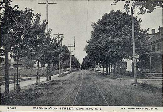
Getting to know Cape May
While trying to get to know a little more about Cape May County, I found that WestJerseyHistory.Org has a great collection of postcards online that give a real sense of the place. It is a much more extensive collection than at Penny Postcards.
Some are a little more touristy:

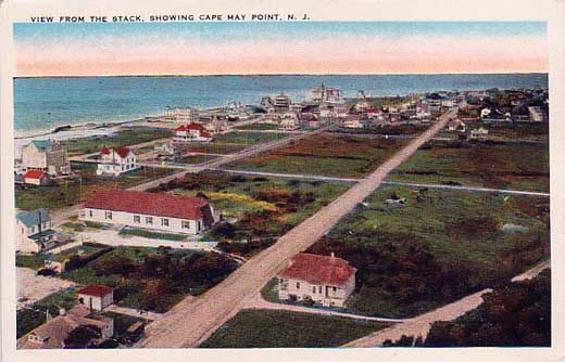
While other capture the real life of the locals:
Some are a little more touristy:
While other capture the real life of the locals:
28 July 2009
Real sketching
For those who mistook the student seminar and last post as a vote for all-digital all-the-time, Laura's sketchblog shows how there are some things that can only work on paper.
New student orientation
I am meeting with some freshmen first year students today.
I'll be talking about some VGI and PPGIS issues for designers, building on my First Monday paper and using examples like Common Census, Wikimapia (before the update), Second Life, and Vernal Pools.
I'll be talking about some VGI and PPGIS issues for designers, building on my First Monday paper and using examples like Common Census, Wikimapia (before the update), Second Life, and Vernal Pools.
27 July 2009
Train under Sagrada Familia moving ahead
When we were in Barcelona, a controversy was growing over whether to locate a train line directly beneath the cultural icon of the city, Gaudi's Sagrada Familia. It has been decided thatSpain's national courts will supervise the work to protect the important monument. Just in case it doesn't work and the building crumbles, here's a Places and Spaces tribute to minor details of Sagrada Familia...


25 July 2009
"Planning aide" caught in NJ snare
Amongst the 44 NJ politicians, rabbis, and body parts traffickers arrested Thursday was a Jersey City official described as a planning aide. According to PolitickerNJ.com:
It is one more piece of evidence that the planning and zoning world is a bit more high-powered than might first seem obvious on your local access or government affairs channel.A planning aide with the city of Jersey City, Catrillo is charged with accepting $5,000 in exchange for the promised delivery of project approvals for a federal cooperating witness, who posed as a developer.
24 July 2009
Geospatial Revolution video
Penn State is pushing the geosptial revolution with a preview video looking at how location has changed in modern life. The project is "an online rolling release of an eight-episode series, featuring national and international geospatial stories." David DiBiase points out that "it has made geography ordinary, which is the most resolutionary thing of all."
23 July 2009
Engaging streetscape
On our most recent visit to DC we saw the new Newseum streetscape along Pennsylvania Avenue which has displays of "today's" front pages from aruond the country and world. As we walked along we could see 100 different ways that papers paid tribute to Walter Cronkite as well as seeing which local stories knocked him off lede. Every day the walk is different.

Even if you can't take a stroll down Pennsylvania Avenue, the Newseum has arranged for you to enjoy today's headlines as laid out for print in their daily Front Page gallery and some might be interesting to planners and designers. Today's headlines include a story about tree roots and hurricanes of the past.
The day we were there another plant got some attention:

more roads quotes
“In the Roman Empire. . . all roads led to Rome. In America, all roads lead to other roads.”
- Phil Patton, Open Road
22 July 2009
Cool Class: See, note the cenotes

Mexico has an unfair proportion of the world's cenotes. Those are those giant cave/groundwater/hole things that people like jumping into. Now's your chance to see them, some ancient ruins, some incredible ecosystems and maybe a beach.
Rutgers Study Abroad is working with the LA Department to offer a 3-credit winter class on the Cultural and Ecological Landscapes of the Yucatan that will expand your multicultural studies while keeping you out of trouble during the break.
The ecology alone should be worth it, but the timeline of history there is amazing. But sign up now if you can, because when everyone gets back for the fall it may be too late.


21 July 2009
Congressional hearing on Thursday
Why watch TV when you can watch the Internet?
Some of the more interesting witnesses include Siderelis and Batzli. And you can track the bill online.
"The House Natural Resources Committee, Subcommittee on Energy and Mineral Resources, led by Rep. Jim Costa (D-CA), will hold an oversight hearing on "Federal Geospatial Data Management.""My research interests will focus me more on the first part, but the second seems worthwhile too. Although New Jersey is not presently a participant in the AmericaView program, it seems likely that we might be in the future. Especially with Congressman Holt serving on this subcommittee.
Link: http://resourcescommittee.house.gov/index.php?option=com_jcalpro&Itemid=27&extmode=view&extid=278
This hearing will be directly followed by a legislative hearing on the following bill:
H.R. 2489 (Herseth Sandlin): To authorize a comprehensive national cooperative geospatial imagery mapping program through the United States Geological Survey, to promote use of the program for education, workforce training and development, and applied research, and to support Federal, State, tribal, and local government programs. "AmericaView Geospatial Imagery Mapping Program Act."
Some of the more interesting witnesses include Siderelis and Batzli. And you can track the bill online.
20 July 2009
DC hike
On Sunday morning I led a hike for RU students and alums (and even a few Princetonians) around the East end of the National Mall. While there were plenty of interesting stops, the cameras really seemed to get unleashed at I. M. Pei's East Wing of the National Gallery. I had a great time and hope any of you who joined us did too.


17 July 2009
Wilderness battle
I find planning battles over battlefields to particularly interesting because a battle (especially the Wilderness campaign) occurs across spatially irregular patterns in a landscape that will never be the same as it was that day.
16 July 2009
Rising Tides results
The international design competition, Rising Tides, has wrapped up with an impressive slate of winning entries. The competition seeking design interventions for coping with sea level rise in San Francisco Bay ended in a 6-way tie that captured a breadth of different approaches to this complex problem. One proposal calls for the construction of a series of lasers showing where a huge dike will need to be built all the way around the bay. Another plan tries to imagine the different kinds of first aid that will be required for different stitches - comparing clean up, stitches and major surgery to protection, operation and adaptation. Two others looked at ways to regulate the tidal flows of the bay with hard or soft structures.
Another Rutgers faculty blog
RU professor, Daniel Goldstein, is running a blog for his current study abroad class in Bolivia: bolivia-ru.blogspot.com.
15 July 2009
Obama on cities
The first year of most new administrations is a time of jockeying and reading tea leaves, trying to guess where policy and funding changes will occur. On Monday President Obama framed a new vision for American cities, and you can be sure that plenty of analysts were parsing it yesterday for clues and insight.
It would require "new strategies for our cities and metropolitan areas that focus on advancing opportunity through competitive, sustainable, and inclusive growth."
He did identify two specific program areas, Promise Neighborhoods and Choice Neighborhoods:
It would require "new strategies for our cities and metropolitan areas that focus on advancing opportunity through competitive, sustainable, and inclusive growth."
He did identify two specific program areas, Promise Neighborhoods and Choice Neighborhoods:
Now, we began to do just that with my budget proposal, which included two investments in innovative and proven strategies. I just want to mention these briefly. The first, Promise Neighborhoods, is modeled on Geoffrey Canada's successful Harlem Children's Zone. It's an all-encompassing, all-hands-on-deck effort that's turning around the lives of New York City's children, block by block. And what we want to do is to make grants available for communities in other cities to jumpstart their own neighborhood-level interventions that change the odds for our kids.
The second proposal we call Choice Neighborhoods -- focuses on new ideas for housing in our cities by recognizing that different communities need different solutions. So instead of isolated and monolithic public housing projects that too often trap residents in a cycle of poverty and isolate them further, we want to invest in proven strategies that actually transform communities and enhance opportunity for residents and businesses alike.
Can you imagine one or two of these around you? Let's assume that planners all over are already highlighting areas on their digital maps and checking the data to prove it. And leave it to the Chicagoan to sneak in a little Dan Burnham.14 July 2009
Drawings with little black lines on it
This great quote of an attorney, Darren Leotti, appeared in an article on some zoning changes in Readington:
That pretty much sums up the world of zoning changes right there.
"It seems esoteric when reduced to drawings with little black lines on it," he said, but argued that this has a real affect on what his client can do with his
land.
That pretty much sums up the world of zoning changes right there.
13 July 2009
GIS and Design
This morning the ESRI USer Conference will hold its opening plenary with the conference themed around GIS–Designing our Future. Jack Dangermond will be giving an opening talk looking at the intertwined roles of GIS and Design. In the printed version he references Stenitz's Framework and quotes Neutra. It isn't a coincidence that he is trained as a landscape architect and successful as a GIS innovator.
These two paths are linked (although sometimes awkwardly) and the relationship was recently explored with a special two-day workshop on Spatial Concepts of GIS and Design at UCSB. The participant list alone is a great resource.
I just hope the sunny weather in San Diego won't blind the audience from seeing the significance of this critically important intersection.
10 July 2009
FREE Workshop on Grants for Planning and Designing Climate-Friendly Towns
I never know how to summarize these things, so here is the whole announcement that I received:
Workshop for DEP Grants:
Planning and Designing Climate-Friendly Towns
Monday, July 20, 2009
10 a.m. to 12 noon
Edward J. Bloustein School, Room 113
33 Livingston Avenue, New Brunswick
On June 18th, the NJ Department of Environmental Protection (DEP) announced a new grant program for municipalities and counties: the Local Government Greenhouse Gas Reduction Program. This workshop will focus on one aspect of the grant program: the development and implementation of climate-friendly design guidelines and zoning standards that allow for compact, walkable mixed-use development and/or transit-oriented development.
Speakers will present successful planning initiatives and approaches that are eligible for this grant category. DEP staff will be present to answer questions about all aspects of the grant program, including the application process, deadlines and qualifications. (Grant amounts for this category range from $25,000 - $200,000. Click Here for more information on the grant program.)
Speakers:
Pam Mount, Moderator
Owner, Terhune Orchards; Member, New Jersey Future Board of Trustees;
Vice President, NJLM Mayors Committee for a Green Future
Angus Jennings, AICP
Principal Planner, Concord Square Planning & Development, Inc.
Representative
Borough of Haddonfield, NJ
Elizabeth Semple and Martin Rosen
NJDEP Office of Planning and Sustainability
The Edward J. Bloustein School is located at 33 Livingston Avenue in downtown New Brunswick. Click here for directions and area map with parking information.
This workshop is provided at no charge; however, registration is required. Please contact Marianne Jann at New Jersey Future: mariannejann@njfuture.org or 609-393-0008, x101.
________________________________________
Event Partners
American Planning Association - NJ Chapter • Association of New Jersey Environmental Commissions • Congress for the New Urbanism - NJ Chapter • County Planners Association Mercer County Chamber of Commerce • Municipal Land Use Center • PlanSmart NJ
Regional Plan Association • Sustainable Jersey • Tri-State Transportation Campaign
Voorhees Transportation Center
09 July 2009
Multiple skillsets
Can you name the member of the US Senate who can draw a map of the 50 states in less than 2 minutes? The Map Room has the answer.
08 July 2009
Maya Lin on WNYC
Maya Lin appeared on the Leonard Lopate Show to discuss her new installation at Storm King, Wavefield. The video below is short, so you should listen to the whole show, too.
07 July 2009
More than a subway map
I was in the CIty this weekend and enjoyed using an iPhone app for my Subway maps instead of staring at the big wall maps. but now they've gone a step further with Subway platform maps.
What to see in New York?
Time to reassess your summer. For those in the tri-state area it might mean asking, Have you made the most of your trips to New York and around its vicinity?
To start, have you made it to the High Line?
Have you seen the new Thom Mayne building at Cooper Union?
Have you seen the cleaned up, 50-year old Guggenheim Museum with its special exhibit on Frank Lloyd Wright?
You are going to the Museum of the City of New York (up near the Harlem Meer) to see Eric Sanderson's Mannahatta exhibit, right? (E.S. is a former and future speaker series speaker)
On July 14th the Hispanic Society of America in Harlem has an experience about how sound can organize the experience of space.
You can wait until Fall to visit Storm King to see the new Maya Lin installation and the temporary exhibit.
Here on our side of the Hudson you could head down to the Princeton Art Museum for a free exhibition signaling the retirement of former speaker series speaker, Yoshiaki Shimiku called Memorable Encounters from Hōnen to de Kooning: In Honor of Yoshiaki Shimizu.
Peek at the progress at Brooklyn Bridge Park
And, of course, you have to lounge around Times Square.
06 July 2009
Walking Berlin by Fantastic Nroway
Fantastic Norway recently implemented a project called Walking Berlin where they dressed up as a building and walked around. Dezeen has the pictures (which is good, because my description is a bit weak).
Weekend catch-up
There was plenty of news in this weekend's papers. Much I was happy to overlook or forget in the spirit of the holiday, but here were a few of varying interest:
- Newark has to give back the money for Military Park
- ASLA's The Dirt is tracking the Climate Change Bill
- Cumberland County is moving forward with its county open space plan
- Should Fairfax be a City or County and what should it be like?
- The NYTimes has reviewed the Mannahatta museum exhibit with a slideshow
- New Orleans tops the list of fastest growing cities along with Round Rock, TX (an Austin suburb that wasn't even in the Top 25 last year) complete with slideshow
03 July 2009
Fall Studio: Sea Level Rise
When you think of Cape May, you probably think of old Victorians and great beaches, not a community at risk. This fall in studio, we will be changing our perspective a bit.

While I am still unprepared to reveal all of the final details, I wanted to share the basic outline of our fall studio project for Intermediate Landscape Architecture I (11:550:331). The entire semester will be spent exploring design interventions and implications of sea level rise and global warming in Cape May County, New Jersey with funding assistance from the New Jersey Chapter of the American Society of Landscape Architects.
The project will be building on the results of the Spring 2009 Advanced Environmental Geomatics class. CRSSA has already created some great research on the Vulnerability of New Jersey's Coastal Habitats to Sea Level Rise that will give you a sense for both the seriousness of the threat and the diversity of issues wrapped up in this seemingly simple problem. SEBS researchers and Rutgers alums are all looking into the problem.
Cape May County has become the high profile location of an ecological decline that is represented in the falling populations of the interconnected populations of red knots and horseshoe crabs. This got some national attention when PBS aired an entire episode looking at the problem, but has been the focus of research here at Rutgers and at the NJ DEP for some time. It is also a great spot for ecotourism, which would presumably decline quickly as the natural landscapes are degraded.

One of the clear challenges would be to start building an infrastructure now that will better support the future residents of Cape May County. What would high performance infrastructure guidelines tell us about where we should be looking? We aren't the first people to explore these topics, so we need to learn from past studies if we are going to accomplish something new.
The certain threat and the uncertain details make sea level rise, and the larger patterns of climate change, an interesting problem for designers. In the San Francisco Bay Area, concerns about sea level rise (as shown in their local paper) led to the Rising Tides Competition this summer. Hopefully we'll get to see some results this fall before we are too far along in our project. I strongly encourage our students to look back at the IFLA 2008 Student Competition, which gives some great ideas about both the imaginative and serious aspects of this as a design issue.
You should also take a little time to peruse both popular portrayals and serious discussions of climate change and sea level rise. Keep an eye on regular news accounts about the science. How are going to communicate the complexity of the issue? How are we, as a class and a team, going to resolve uncertainties? Do we need to educate the public or are they fairly aware? We'll be sifting through countless agency reports, like the recent EPA report on Adaptation Planning for the National Estuary Program, and trying to organize the things we learn from them. We are also going to start paying attention to more and more mundane things like maps of sidewalks. Keep your eyes (and browser) open for these and keep careful records of what you see.
If you can get out and explore, it would be great. But if you can only get to Trenton, that would work too. The New Jersey State Museum in Trenton also has an exhibit called Rising Tide: Climate Change & Sea Level Rise in New Jersey.
But take some time to get to know Cape May County. Think about the landmarks and people. What is it known for? What is it like for tourists? But what is it like for year-round residents?
Finally, Places and Spaces will now be an active focused source with at least 3 tags for this project: cape may, JrStudio, sea level rise. Use them to keep up.
02 July 2009
Data.gov
The federal government has started posting its datasets on engines at Data.Gov and the raw data catalog includes shapefiles, KML/KMZs, and maps (is it really over 100,000?). But it also has a separate Geodata Catalog that may be of greater interest to our readers. But it isn't done yet. And now the challenge is to make something out of it.
01 July 2009

Subscribe to:
Posts (Atom)


