The map has gone 8-bit.(h/ t NH) Even StreetView is altered, which makes it fun to look at landmarks. But hurry, this effect will be gone after Sunday night. As you prepare for the holiday, check out our posts from past years.
Late update: Google has added a great video describing this upgrade
31 March 2012
30 March 2012
Wind map
Check out this very cool geovisualization of win in the US, as of right now. (h/t Kathleen)
Test notes
Thursday April 5
Same format as last time
The usual seating rules apply
Readings:
Same format as last time
- #2 pencils
- True/False and multiple choice
The usual seating rules apply
Readings:
- Chapters 5-8
- Strom notes on suitability analysis
- ANJEC sections on municipal planning and zoning
Community Mapping in Seoul
As part of my visit to Seoul, I joined Dr. Wansoo Im and IMKorea in a community mapping exercise. The exercise was joined by Seoul's mayor Won-soon Park (pdf). He used both and iPhone and iPad to photograph, map, and describe places in the city where there were unnecessary challenges for people with disabilities.


29 March 2012
Office Hours cancelled
Unfortunately I need to cancel my office hours for Tuesday April 3rd. I will have office on Wednesday at 1 at Blake Hall 220.
I have added appointments to my sign-up sheet at ENR 133 and may add more. I also still have one left for Friday the 30th.
I have added appointments to my sign-up sheet at ENR 133 and may add more. I also still have one left for Friday the 30th.
Summer class
Hey SEBS students!
Did you know that you can fulfill a political processes requirement with a hybrid course this summer
Did you know that you can fulfill a political processes requirement with a hybrid course this summer
Global Environmental Change 11:374:102?
Introduction to Human Ecology 11:374:101 will also be offered.
Check the Schedule of Classes online for more details.
Computers get bigger and dataier
Rutgers pushes into supercomputing and the Obama administration is putting $200 million into 'big data'.
28 March 2012
Changdeokgung Palace
The highlight of the trip was my visit to the Changdeokgung Palace and its Secret Garden. The site is deservedly designated as a UNESCO World Heritage Site, truly one of the great human-built sites anywhere. Throughout the site, appreciation of nature and balance of design elements were the recurring theme.


Are solar farms better than farms?
Barry Chalofsky writes in the Times of Trenton about the dilemma of solar farms.
27 March 2012
Wright quote
“Early in life I had to choose between honest arrogance and hypocritical humility. I chose the former and have seen no reason to change.”
- Frank Lloyd Wright
26 March 2012


25 March 2012
Innovation at Bell Labs
The NY Times recently ran a fascinating feature on the innovation factory that was New Jersey's Bell Labs. Diane Rehm had on author Jon Gertner to talk about his book, The Idea Factory: Bell Labs and the Great Age of American Innovation. Between Bell Labs and Edison, New Jersey seems like an idea-rich innovation landscape.
Can bikes be too popular?


24 March 2012
Reflecting on Ian McHarg
I've recently had the occasion to, yet again, reflect on the work and career of Ian McHarg. This time I stumbled onto the NY Times obituary from his death in 2001. If you doubt his impact, just note how long the obit is, in the paper of record. I count it at 1,100 words, which is substantial.
The obituary paints him as a grand thinker and a dreamer. Niall Kirkwood reflected that, "The last thing he said to me, last April or so, was, `I want to do this big study, a geophysical inventory for the whole globe, the world,'" Mr. Kirkwood said. "He was still dreaming far beyond his circumstances." It also pointed out the costs of dreaming, quoting him as saying that "it might just be possible now to avoid dying bankrupt."
But it is also interesting to note that it doesn't talk about his use of overlays or influence on GIS. Admittedly, it was a newspaper obit and not one from a planning journal. But it may be as telling.
23 March 2012
Check out the poll -->
Only for students in 372:231 Fundamentals of Environmental Planning: Please take the poll, even if your answer is "Don't Care". We need to resolve this in the next few days!
Seolleung Park
As the burial grounds of two Joseon kings and one Joseon queen, this park is a unexpectedly nice setting for a morning walk near Seoul's Teheranno and some of the tallest buildings in the city. Another grey day, but worth a quick peek. Especially since it is part a of collection of properties that have UNESCO World Heritage status.


The Proposed Eisenhower Memorial
Witold Rybczynski offers some thoughts on the current controversy over the proposed Eisenhower Memorial in Washington DC. The LA Times and Washington Post also weigh in. The Post offers some pretty some strong feelings hoping that we can still fix this to prevent it from becoming another WWII memorial.
22 March 2012
Cerda's Barcelona
After today's conversation in class about Cerda's plan for Barcelona, this video might help illustrate the basic elements and context of the plan.
Schedule question
April is a tough time of year for scheduling around religious holidays. In Fundamentals of Environmental Planning, the 2nd test is currently schedule for Thursday April 5th, which appears to be the Thursday before Protestant/Catholic Easter (Orthodox Easter is the 15th) and before what I am told is the beginning of passover (~6th-15th). But for those traveling for these holidays, it is hard to figure whether the 5th is better than the 9th.
Let me know what you think. Vote in the poll on the right -->
Of course, missing for a religious holiday will be excused. But it would be best if we could arrange this to work for the most people. Our default will be the syllabus (April 5th) but a small delay that pleases many will be considered.
Let me know what you think. Vote in the poll on the right -->
Of course, missing for a religious holiday will be excused. But it would be best if we could arrange this to work for the most people. Our default will be the syllabus (April 5th) but a small delay that pleases many will be considered.


21 March 2012
Cartographic Modelling
After talking in class about Dana Tomlin's Cartographic Modelling tools of
- Local
- Focal
- Global
- Zonal
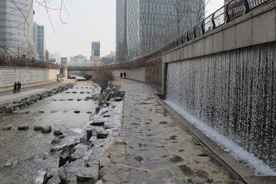
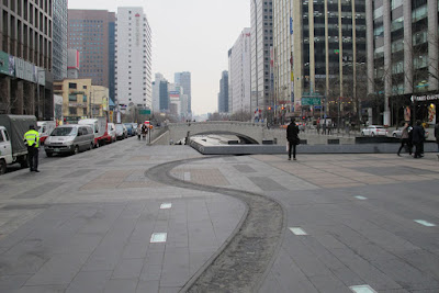
Cheonggyecheon restored river
One of the most notable examples of modern landscape architecture is Seoul's Cheonggyecheon. It represents the relatively new trend of trying to recover elements of lost ecology while still inserting new elements of urban design. The NY Times reviewed this revolutionary design in 2009 and was able to take photos that were less gloomy than mine.
My personal experience was that I was surprised by the variety in experiences. There are sections that work to replicate natural processes (as much as you can in a concrete canyon). And others that work for a modern, urban hardscape feel. As a daylighted stream, it helps soften the 2nd largest city in the world. And, at a reported 5km long, it leaves a noticeable footprint in the urban landscape.

More photos after the jump...
My personal experience was that I was surprised by the variety in experiences. There are sections that work to replicate natural processes (as much as you can in a concrete canyon). And others that work for a modern, urban hardscape feel. As a daylighted stream, it helps soften the 2nd largest city in the world. And, at a reported 5km long, it leaves a noticeable footprint in the urban landscape.


More photos after the jump...
20 March 2012
Spring is here!
To celebrate the sun's crossing of the equator, I thought I'd share my first flowery photos of the spring. These show the cherry blossoms popping out at Tongdosa, the largest temple in South Korea and truly a national treasure. These were the only cherry blossoms I saw during spring break, since Tongdosa is in southern South Korea (near Ulsan) and I spent most of the trip in Seoul. It is one of the three jewel temples of Korea, but the only one I made it to. And I thank my new friends from UNIST, because I never could have gotten to the rather remote site without them.
Enjoy these and keep watching for more Korean spring break photos in the coming days.


Lots more photos of this beautiful temple after the jump...
Enjoy these and keep watching for more Korean spring break photos in the coming days.


Lots more photos of this beautiful temple after the jump...
15 March 2012
A few extra readings on PPGIS, VGI and data sharing
After some presentations this week, I have gotten requests for more information than I was able to cover. So here are three free and online papers that I humbly offer to continue that conversation:
So far, the audiences for these talks have been incredible. And I hope to share a little more about this over the next few days.
Stay tuned...
- Tulloch and Shapiro on Access and Participation
- Tulloch and Harvey on Data Sharing Practices
- Tulloch on PPGIS in First Monday
So far, the audiences for these talks have been incredible. And I hope to share a little more about this over the next few days.
Stay tuned...
14 March 2012
Next Week: Women in Landscape Architetcure

An exciting line up for you when you return from Spring Break.
13 March 2012
Open Source GIS software
Directions Magazine has the Top 10 things you need to know about open source GIS software.
NRCS Internship
STUDENT TRAINEE POSITIONS: The Natural Resources Conservation Service (NRCS) is recruiting students to participate in our Student Career Enhancement Program (SCEP). This program provides Federal employment opportunities to students who are enrolled, or accepted for enrollment, in a degree program. Students must be taking at least a half-time academic course load in an accredited 2 or 4-year college or university, graduate, or professional school.
Opening Date: March 12, 2012
Closing Date: April 9, 2012.
Salary: $14.03 - $15.70 per hour based on the number of college credits earned.
Open to U.S. Citizens Only
LOCATION: The locations will be determined following a review of the applications.
HOW TO APPLY: Applications must include:
HOW TO APPLY: Applications must include:
1. Resume (include work experience even if wages were not received)
2. Copy of current college transcript
3. A list of courses in which currently enrolled, those planned for the Spring/Fall Semester of 2012 and your expected graduation date
4. DD-214 if claiming veteran preference
Be sure to include phone number(s) where you can be reached, your permanent residence address and a current email address.
Students will be assigned to work at various training locations throughout the State of New Jersey.
Applications must be received at the following address by the closing date listed.
USDA-Natural Resources Conservation Service
Human Resources Manager
Human Resources Manager
Mayra L. Morales
220 Davidson Avenue – 4th Floor
220 Davidson Avenue – 4th Floor
Somerset, NJ 08873
Email: Mayra.Morales@nj.usda.gov
12 March 2012
Most dangerous highways for walking in New Jersey
The Tri-State Transportation Campaign has a new report out identifying the most dangerous highways for walking in New Jersey. Rutgers readers won't be surprised to see the nearby stretch of US 1 on the list. The state has already tried putting up fencing above the Jersey barriers to prevent pedestrians. But when you separate residential areas from nearby services (food, work, convenience stores), the residents will need to get across.
Uncertainty for affordable housing
We are still wondering what will happen to affordable housing in New Jersey?
08 March 2012
Suitability Analysis notes from Steve Strom
Here are the old handwritten Suitability Analysis notes from when Steve Strom used these techniques in his studio. This four page set of Suitability Analysis notes is online now as a PDF. His description of weighted analysis lacks a graphic, so I created a digital version of both some of his graphics and a new Weight and Rate graphic that should help you work through it all as you look ahead to our next exam: To be clear, each grid shows the very same piece of land but being rated for a different issue (soils, slope, vegetation). Presumably that is fairly objective. But each individual criterion is then weighted based on relative importance. In this case, Slope has rather subjectively been weighted as 5 times more important that Vegetation. If you click on my graphic it will enlarge and be more readable.
To be clear, each grid shows the very same piece of land but being rated for a different issue (soils, slope, vegetation). Presumably that is fairly objective. But each individual criterion is then weighted based on relative importance. In this case, Slope has rather subjectively been weighted as 5 times more important that Vegetation. If you click on my graphic it will enlarge and be more readable.
07 March 2012
Live Blog: Britt Eversole: Militant Mapping
Britt Eversole
Militant Mapping
Examples from the Italian neo-avant garde
The context is a time of turmoil in Italy, with a major role being played by the architecture students
The line between art and activism can be hard to identify
Can maps reveal to us a code that is related to that movement
Maps do things to us and we can do things to them

“A map of the world that does not include Utopia is not worth even glancing at, for it leaves out the one country at which Humanity is always landing. And when Humanity lands there, it looks out, and, seeing a better country, sets sail. Progress is the realisation of Utopias.”
― Oscar Wilde, The Soul of Man under Socialism
"Prince Modupe, I Was A Savage, how he had learned to read maps at school, and how he had taken back home to his village a map of a river his father had traveled for years as a trader:
"...my father thought the whole idea was absurd. He refused to identify the stream he had crossed at Bomako, where it is no deeper, he said, than a man is high, with the great widespread waters of the vast Niger delta. Distances as measured in miles had no meaning for him.... Maps are liars, he told me briefly. From his tone of voice I could tell that I had offended him in some way not known to me at the time. The things that hurt one do not show on a map. ... With my big map-talk, I had effaced the magnitude of his cargo-laden, heat-weighted tracks."
- Marshall McLuhan
1. Maps are documents
But of course they are more than that
 Another example was a Taliesin Square Paper by FLW that show how he would like to refederate the US into 3 sections: Usonia, Usonia South, and New England.
2. Maps are Representations of Space
3. Maps are (Seemingly) Authorless Documents
Unlike other documents, we read them as if they were authoritative
Massimo Vignelli's NYC Subway map was an example
 Sanborn maps have similar characteristics

Back to Italy, we see historic maps of Italy being treated as important because they give the city form.

 Mussolini's linkage communication and movement was key to empowering his fascist regime, liking these with a return to Italian greatness.
Change came to the landscapes of Italy and the conflict was captured in the film, Le mani sulla città.

The use of models and maps throughout the movie, forsaged their growing presence in post-war Italy as it underwent dramatic change. Walking through the map (literally a giant wall map with a door in it) marks the symbolic crash for the aggressive developer played by Rod Steiger.
Alighiero Boetti
 Each year a different map was woven but with different projections and boundaries that he specified.

The talk turned to poets whose work led them to cartography as an alternative media for their art. They used the way that maps have codes and the ways that we are programmed to respond to them.
These artistic modifications of old maps were militant mapping that addressed the turmoil of redial Italy.
This was really an idea rich presentation which is currently an early draft of a larger project. I can't claim to have captured the big ideas, so I settled for some smattering of details.
Militant Mapping
Examples from the Italian neo-avant garde
The context is a time of turmoil in Italy, with a major role being played by the architecture students
The line between art and activism can be hard to identify
Can maps reveal to us a code that is related to that movement
Maps do things to us and we can do things to them
“A map of the world that does not include Utopia is not worth even glancing at, for it leaves out the one country at which Humanity is always landing. And when Humanity lands there, it looks out, and, seeing a better country, sets sail. Progress is the realisation of Utopias.”
― Oscar Wilde, The Soul of Man under Socialism
"Prince Modupe, I Was A Savage, how he had learned to read maps at school, and how he had taken back home to his village a map of a river his father had traveled for years as a trader:
"...my father thought the whole idea was absurd. He refused to identify the stream he had crossed at Bomako, where it is no deeper, he said, than a man is high, with the great widespread waters of the vast Niger delta. Distances as measured in miles had no meaning for him.... Maps are liars, he told me briefly. From his tone of voice I could tell that I had offended him in some way not known to me at the time. The things that hurt one do not show on a map. ... With my big map-talk, I had effaced the magnitude of his cargo-laden, heat-weighted tracks."
- Marshall McLuhan
1. Maps are documents
But of course they are more than that
2. Maps are Representations of Space
3. Maps are (Seemingly) Authorless Documents
Unlike other documents, we read them as if they were authoritative
Massimo Vignelli's NYC Subway map was an example
Back to Italy, we see historic maps of Italy being treated as important because they give the city form.
Change came to the landscapes of Italy and the conflict was captured in the film, Le mani sulla città.
Alighiero Boetti
The talk turned to poets whose work led them to cartography as an alternative media for their art. They used the way that maps have codes and the ways that we are programmed to respond to them.
These artistic modifications of old maps were militant mapping that addressed the turmoil of redial Italy.
This was really an idea rich presentation which is currently an early draft of a larger project. I can't claim to have captured the big ideas, so I settled for some smattering of details.
Subscribe to:
Posts (Atom)


