Mannahatta: A Natural History of New York City
The Fall 2009 Environmental Planning Lecture
So right up front we have to acknowledge that today's talk brings with it some extra attention. The Mannahata Project has a highly visible website with data as well as plenty of attention from the NY Times and WNYC's Leonard Lopate Show. Rutgers alum Kate John-Alder recently wrote a review in the Architect's Newspaper. If you want depth, you should start with Kate's review. This is just a LiveBlog...
MuirWeb and Mannahatta - making the invisible, visible
Mannahatta, the isle of many hills
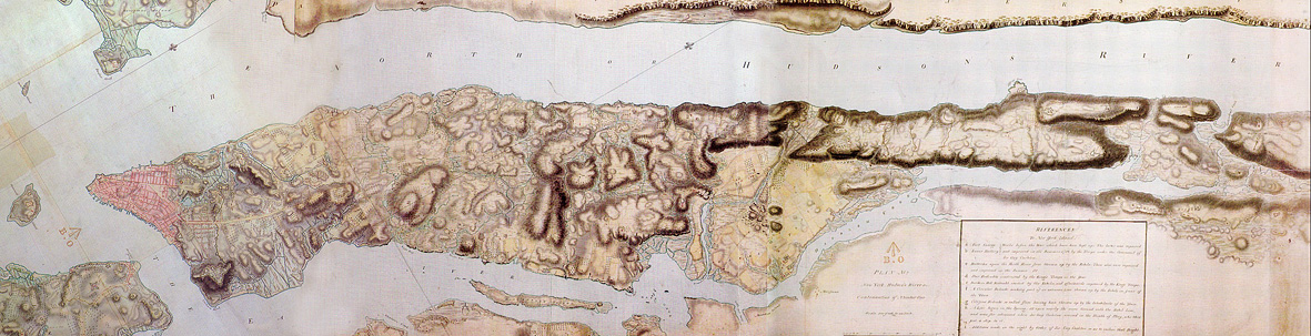
It all started with a map found
His work at the World Conservation Society (Bronx Zoo) led him to this map that went back before the usual early histories
. . . . Father Duffy
 NYC was the first megacity - Now there are 18, soon there'll be 27
1782 or 1783

Fort Kniphausen - Fort Washington
What if we could take the streets off and go further back in time.
Sanderson's team made an historic DEM, added spotty data, and ran a human habitat model
. . the best places were around Collect Pond, near Chinatown and City Hall
. . . similarly they could look for Lenape field where they might have grown the three sisters - corn, beans, and squash
. . . they could model the 55 different ecosystem types that came up as most likely - he thinks of these as being the neighborhoods for plants and animals - more than Yellowstone has on a per acre basis
Sorry, no PowerPoint comas today. This was an ArcGIS dependent presentation.
Home Reconstructed
He enjoys looking for similar landscapes to the original places
- Hempstead Plains Grassland
- Coastal Appalachian Oak-Pine Forest
- Rocky Headwater Stream
- High and Low Salt Marsh
Animals were plentiful
- Beavers were probably o all 66 miles of streams
- Heath hens
- Deer and maybe elk
- Wolves
- Black bear
- Food
- Water
- Shelter
- Reproductive resources
It features a density of relationships that make it robust, dynamic and resilience
The MuirWebs are named for John Muir (a real shaper) who said:
"When we try to pick out anything by itself, we find it hitched to everything else in the Universe."
With Markley Boyer he then illustrated the best estimation of how it looked.
The old and new are both pretty special. Can it last for another 400 years?
As his epilogue, he points out how humans need more than Food, Water, Shelter, Reproductive resources, we also need Meaning. But have we spent so much time worrying about Meaning that we have neglected the others?
What if we brought back the streetcars and added greenroofs? Can we think regionally again?
The #1 agricultural county in the US used to be Queens. Can it come back?
What would it look like then?
View Larger Map


6 comments:
David: How did I know this lecture was going to have an extensive live blog.
I really loved this lecture, he took mapping to the next level. I wish I had seen this before the SBMW project last year.
Mannahatta seems so simple at first glance, but the depth was remarkable.
:)
I liked how the lecture included alot of ArcMap because I actually understood what was going on since we are learning about ArcMap in studio. I think it was very much related to our studies. It also made me want to go to Manhattan right NOW.
It was freshing to hear Dr. Sanderson talk about ecological communites as individual neighborhoods. It really makes you look deeper into the way we live, and how buildings, roads, etc, are all part of the human ecosystem.
Additionally I really liked it when he imagined the cities surrounding NYC being as densely populated, and showing how much room for farmland would be left.
p.s. That DEM map was intense.
I really appreciated the way Dr. Sanderson presented the project. It was especially helpful in light of this year's studio that he explained his process and thoughts all along the way. And hearing how he walks around Manhattan and imagines what certain areas must've looked like 400 years ago was really interesting. I think that as landscape architects we need to constantly remind ourselves that the landscape is a dynamic ever changing thing, and Manhattan is just an example of that.
His ending thoughts about how humans have a unique need for meaning in life were also inspiring. It's so easy to focus and succeed in one or a few of those areas but we need to make sure that we're stepping back and looking at the big picture to make sure our successes aren't lop-sided.
Today’s lecture was uniquely fascinating and adventurous. I find it amazing that so much information can be gathered based on a map, paintings, and other data can be combined to create Mannahatta.
For me the most interesting part of the lecture occurred when Eric spoke of the probable bio diversity in a given area and how they are linked by habitat. I also enjoyed the visual stimulation of the photos.
Eric Sanderson did so much research for his book and it definitely paid off. The information that he presented was extremely interesting and made me want to learn more about the history of Manhattan. It gives you a whole new perspective about NYC and makes you think about what happened before we turned it into what it is today. The maps that he walked us through were informative and furthered his points. Can't wait to read the book!
Post a Comment